| Serramonacesca | |
|---|---|
| Comune | |
| Comune di Serramonacesca | |
 | |
 Coat of arms Coat of arms | |
| Location of Serramonacesca | |
  | |
| Coordinates: 42°15′N 14°06′E / 42.250°N 14.100°E / 42.250; 14.100 | |
| Country | Italy |
| Region | Abruzzo |
| Province | Pescara (PE) |
| Frazioni | Colle Serra, Garifoli, San Ienno san Gennaro |
| Government | |
| • Mayor | Franco Enrico Marinelli |
| Area | |
| • Total | 23 km (9 sq mi) |
| Elevation | 280 m (920 ft) |
| Population | |
| • Total | 561 |
| • Density | 24/km (63/sq mi) |
| Demonym | Serresi |
| Time zone | UTC+1 (CET) |
| • Summer (DST) | UTC+2 (CEST) |
| Postal code | 65100 |
| Dialing code | 085 |
| Website | Official website |
Serramonacesca is a comune and town in the province of Pescara in the Abruzzo region of southern Italy.
Main sights
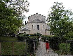
- Abbey of San Liberatore a Maiella
- Hermitage of Saint Onofrio
- The Polegra Tower
- Castel Menardo
- Rock-cut tombs of San Liberatore
- Rock-cut complex of San Liberatore
References
- "Superficie di Comuni Province e Regioni italiane al 9 ottobre 2011". Italian National Institute of Statistics. Retrieved 16 March 2019.
- "Popolazione Residente al 1° Gennaio 2018". Italian National Institute of Statistics. Retrieved 16 March 2019.
External links
- Official website (in Italian and English)
This Abruzzo location article is a stub. You can help Misplaced Pages by expanding it. |