| Sespe Hot Springs | |
|---|---|
| Sespe hot river | |
 Sespe Wilderness Sespe Wilderness | |
| Location | near the Sespe Condor Sanctuary in California |
| Coordinates | 34°25′40″N 118°59′52″W / 34.42778°N 118.99778°W / 34.42778; -118.99778 |
| Elevation | 2,700 feet |
| Type | geothermal |
| Discharge | 380 liters/minute |
| Temperature | 90 °C (194 °F) |
Sespe Hot Springs (Chumash: S'eqp'e') are a system of thermal springs and seeps that form a hot spring creek in the mountains near the Sespe Condor Sanctuary near Ojai, California.
Description
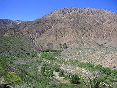
The hot springs were used for centuries by local indigenous people for their warmth and healing properties. The hot springs and hot creek are located in a remote desert mountainous area in Los Padres National Forest. The hot mineral water emerges from the ground at 194 °F / 90 °C through a series of seeps that flows down a hillside, cooling as it enters several primitive, rock and boulder-lined soaking pools. The temperature of the water cools as it mixes with cool water from a creek. Several seeps along the creekside emerge at cooler temperatures than the main springs. At the site, there is also a primitive rock sauna, and a hot waterfall.
Location
The hot springs are located 20 miles northeast of Sespe Creek canyon, approximately 20 miles from Matilija Canyon and 15 miles south of the San Andreas Fault. The hot springs are accessible on foot or by horseback only. There are three rugged trails leading to the springs. The springs can be reached via the Sespe River Trail (16.8 miles each way); the Johnson Ridge Trail (9.5 miles each way); and the Alder Creek Trail (7.5 miles each way). Willett Hot Springs are also located in the Sespe Wilderness area.
Water profile
The hot mineral water flows from at least four spring clusters on a bank above Sespe Creek, a source on the steep slope, and from seeps in the stream bed gravel. In 1915 the water temperature was measured at 191 °F (88 °C) from one of the springs on the high slope above the creek. The springs on the bank emerge from crushed shale and decomposed granite. In 2008 the spring water was measured at 194 °F (90 °C).
See also
References
- ^ Higgins, Chris T.; Therberge, Albert E. Jr.; Ikelman, Joy A. (1980). Geothermal Resources of California (PDF) (Map). NOAA National Geophysical Center. Sacramento: California Department of Mines and Geology.
- ^ Gersh-Young, Marjorie (2011). Hot Springs and Hot Pools in the Southwest. Santa Cruz, California: Aqua Thermal. pp. 186–187. ISBN 978-1-890880-09-5.
- McCall, Lynne; Perry, Rosalind (2002). California's Chumash Indians : a project of the Santa Barbara Museum of Natural History Education Center. San Luis Obispo, California: EZ Nature Books. ISBN 0936784156. Retrieved 30 October 2020.
- ^ Martín, Hugo (7 December 2008). "Sespe Hot Springs in Ventura County: a hot time in the wilderness". Los Angeles Times. Retrieved 30 October 2020.
- Berry, George W.; Grim, Paul J.; Ikelman, Joy A. (1980). Thermal Spring List for the United States. Boulder, Colorardo: National Oceanic and Atmospheric Administration.
- ^ "Sespe Hot Springs, Ojai Ranger District" (PDF). Los Padres National Forest, U.S. Dept of Agriculture. Retrieved 30 October 2020.
- ^ Waring, Gerald Ashley (January 1915). Springs of California. Water-Supply Paper no. 338–339 (Department of the Interior, United States Geological Survey Water-Supply Papers). Washington, D.C.: U.S. Government Printing Office. p. 66. Retrieved 2023-11-14 – via HathiTrust.
- "Willet and Sespe Hot Springs". Hidden California. Retrieved 30 October 2020.