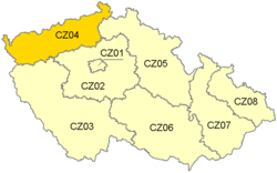
| Severozápad | |
|---|---|
| NUTS2 Region | |
 | |
| Country | |
| Area | |
| • Total | 8,649 km (3,339 sq mi) |
| Population | |
| • Total | 1,106,246 |
| • Density | 130/km (330/sq mi) |
| Time zone | UTC+1 (CET) |
| • Summer (DST) | UTC+2 (CEST) |
| HDI (2021) | 0.833 very high · 8th |
Severozápad (Northwest) is a statistical area of the Nomenclature of Territorial Units for Statistics, level NUTS 2. It includes the Karlovy Vary Region and Ústí nad Labem Region.
It covers an area of 8,649 km and 1,105,932 inhabitants (population density 130 inhabitants/km).
| Year | Pop. | ±% |
|---|---|---|
| 1869 | 944,256 | — |
| 1880 | 1,082,607 | +14.7% |
| 1890 | 1,188,884 | +9.8% |
| 1900 | 1,389,177 | +16.8% |
| 1910 | 1,534,113 | +10.4% |
| 1921 | 1,493,629 | −2.6% |
| 1930 | 1,617,409 | +8.3% |
| 1950 | 978,928 | −39.5% |
| 1961 | 1,061,633 | +8.4% |
| 1970 | 1,094,872 | +3.1% |
| 1980 | 1,144,520 | +4.5% |
| 1991 | 1,126,446 | −1.6% |
| 2001 | 1,124,562 | −0.2% |
| 2011 | 1,104,556 | −1.8% |
| 2021 | 1,068,201 | −3.3% |
| Source: Censuses | ||
Economy
The Gross domestic product (GDP) of the region was 15.2 billion € in 2018, accounting for 7.3% of Czech economic output. GDP per capita adjusted for purchasing power was €19,200 or 64% of the EU27 average in the same year. The GDP per employee was also 64% of the EU average.
See also
References
- "Long-term development of the NUTS 2 cohesion region Severozápad" (PDF). www.czso.cz/ (in Czech). Czech Statistical Office.
- "Population of cohesion regions, regions and districts of the Czech Republic, 1 January 2024". Czech Statistical Office. Retrieved 2024-05-17.
- "Sub-national HDI - Area Database - Global Data Lab". hdi.globaldatalab.org. Retrieved 2024-05-16.
- "Historický lexikon obcí České republiky 1869–2011" (in Czech). Czech Statistical Office. 2015-12-21.
- "Population Census 2021: Population by sex". Public Database. Czech Statistical Office. 2021-03-27.
- "Regional GDP per capita ranged from 30% to 263% of the EU average in 2018". Eurostat.
50°25′0″N 13°30′0″E / 50.41667°N 13.50000°E / 50.41667; 13.50000
Categories: