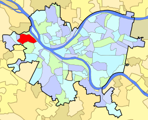
Neighborhood of Pittsburgh in Allegheny County, Pennsylvania, United States
| Sheraden | |
|---|---|
| Neighborhood of Pittsburgh | |
 Langley High School Langley High School | |
 | |
| Coordinates: 40°27′22″N 80°03′29″W / 40.456°N 80.058°W / 40.456; -80.058 | |
| Country | United States |
| State | Pennsylvania |
| County | Allegheny County |
| City | Pittsburgh |
| Area | |
| • Total | 0.69 sq mi (1.8 km) |
| Population | |
| • Total | 5,299 |
| • Density | 7,700/sq mi (3,000/km) |
Sheraden is a neighborhood that is located in the West End of Pittsburgh, Pennsylvania in the United States. Nearby neighborhoods include Windgap, Chartiers City, Crafton Heights, Esplen, and Elliott.
History
This neighborhood was named for William Sheraden, a settler who gave land for the construction of a railroad depot in exchange for the naming rights. Sheraden's original homestead still stands at 2803 Bergman Street, easily distinguished by the two sycamore trees which grew together to form an arch, a legacy of Sheraden's horticulturalist grandson.
Originally incorporated as Sheraden Borough in 1894, this town grew quickly and was annexed by the city of Pittsburgh in 1907. Shortly thereafter, the Pittsburgh school board opened multiple educational facilities around Sheraden, including Langley High School, which was completed in 1923 and replaced the former borough's Riverview High School.
Sheraden grew to become a hub for Irish and German immigrants to Pittsburgh; however, in the 1970s when suburbia increased in popularity, the Irish and Germans moved from Sheraden into Robinson and Crafton. Most of the Irish schoolchildren went to Holy Innocents grade school, which is currently closed along with its parish. Holy Innocents also had a high school.
Education
| This section needs expansion. You can help by adding to it. (April 2019) |
Pittsburgh Public Schools operates public schools. Stevens Elementary School previously served Sheraden.
Recreation
McGonigle Park
This park, located at the end of Allendale Street, features a baseball diamond, batting cage, basketball court, playground, and swing set. Behind the baseball field is a hill that connects to the Chartiers City neighborhood (with beautiful views of the Chartiers Creek).
Mutual Parklet
This small parklet, located on Mutual Street, hosts a basketball hoop, playground, and swing set.
Sheraden Park
Sheraden Park includes a swimming pool, tennis courts, ballfields, outdoor basketball courts and picnic and playground areas.
Sheraden Skate Park
This park, located off of Tuxedo Street, features structures for individuals to use skateboards on.
See also
References
- ^ "PGHSNAP 2010 Raw Census Data by Neighborhood". Pittsburgh Department of City Planning PGHSNAP Utility. 2012. Retrieved 28 June 2013.
- ^ "Sheraden". Pittsburgh City Council official website. Retrieved 16 May 2011.
- Bloom, Albert W. (Jan 14, 1953). "Pittsburgh today made up of many villages". Pittsburgh Post-Gazette. p. 23. Retrieved 2 December 2015.
- ^ "Trinity Evangelical Lutheran Church of Sheraden - Sheraden History". www.trinitysheraden.com. Retrieved 5 March 2018.
- "Thaddeus Stevens Elementary School". Pittsburgh Public Schools. 2004-01-12. Archived from the original on 2004-01-27. Retrieved 2019-04-12.
External links
![]() Media related to Sheraden (Pittsburgh) at Wikimedia Commons
Media related to Sheraden (Pittsburgh) at Wikimedia Commons