 Sherman Way in Reseda Sherman Way in Reseda | |
| Namesake | Moses Sherman |
|---|---|
| Maintained by | Bureau of Street Services, Los Angeles Department of Water and Power |
| Length | 16 mi (26 km) |
| Nearest metro station | |
| West end | Platt Ave. in West Hills |
| Major junctions | |
| East end | Hollywood Burbank Airport in Burbank |
Sherman Way, sometimes called the Way, is a major east–west arterial road that runs for 16 miles (26 km) across the San Fernando Valley in Los Angeles and Burbank, California.
Name
Sherman Way was named after Moses Sherman, a major developer in early Los Angeles.
Due to Sherman Way's prominence as a thoroughfare through the Valley, it is sometimes referred to simply as "the Way", with businesses and organizations naming themselves as being "on the Way", such as The Church on the Way in Van Nuys.
Route
Sherman Way travels east–west across almost the entire San Fernando Valley. From west to east, it travels from West Hills, through Canoga Park, Winnetka, Reseda, Van Nuys, North Hollywood, and Sun Valley, and into Burbank. The majority of the street is four lanes, and much of it contains a median strip.
Sherman Way travels under Van Nuys Airport via the Sherman Way Tunnel, and the street's eastern terminus is at Hollywood Burbank Airport. The street however does not provide direct access to either airport.
Transit
Metro Local Line 162 runs along Sherman Way and the G Line's Sherman Way station is located at Sherman Way and Canoga Avenue in Canoga Park.
The East San Fernando Valley Light Rail Transit Project plans to have a stop at Sherman Way and Van Nuys Boulevard in Van Nuys. Furthermore, four out of the five alternatives for the Sepulveda Transit Corridor include a stop on Sherman Way, either at the 405 freeway or Sepulveda Boulevard.
Notable landmarks

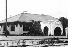
Two Los Angeles Cultural-Historic Monuments (Canoga Mission Gallery and Lederer Residence and Immediate Environments) are located on Sherman Way, and two additional monuments (Pacific Electric Picover Railway Station and Canoga Park (originally Owensmouth) Southern Pacific Railroad Station) were located on Sherman Way before they were destroyed.
Other notable landmarks on Sherman Way include (from west to east): UCLA West Valley Medical Center, Canoga Park Branch Library, Van Nuys Airport, Valley Plaza Sports Complex, and Hollywood Burbank Airport.
Schools on Sherman Way include Magnolia Science Academy 1 and Heart of the Valley Christian School.
References
- Mark Tapio Kines. "Sherman Way". lastreetnames.com. Retrieved September 10, 2024.
- "Metro Local 162" (PDF). Los Angeles County Metropolitan Transportation Authority. Retrieved September 10, 2024.
- "Orange Line Map and Station Locations". Los Angeles County Metropolitan Transportation Authority. Retrieved June 30, 2013.
- Hymon, Steve (June 16, 2018). "Metro staff recommends building light rail between Van Nuys and Sylmar/San Fernando Metrolink Station". Los Angeles County Metropolitan Transportation Authority.
- "Historical Cultural Monuments List" (PDF). City of Los Angeles. Retrieved July 9, 2024.