District of Sindh in Pakistan
| Shikarpur District
ضلع شكارپور شڪارپور ضلعو | |
|---|---|
| District of Sindh | |
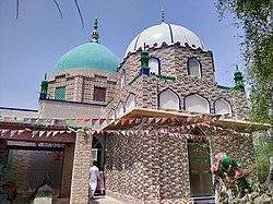
 Shrine in Nim Shareef Shrine in Nim Shareef | |
 | |
| Coordinates: 28°00′N 68°40′E / 28.000°N 68.667°E / 28.000; 68.667 | |
| Country | |
| Province | |
| Division | Larkana |
| Established | 1977 |
| Founded by | Sindh Government |
| Headquarters | Shikarpur |
| Government | |
| • Type | District Administration |
| • Deputy Commissioner | N/A |
| • District Police Officer | N/A |
| • District Health Officer | N/A |
| Area | |
| • District of Sindh | 2,512 km (970 sq mi) |
| Population | |
| • District of Sindh | 1,386,330 |
| • Density | 550/km (1,400/sq mi) |
| • Urban | 318,738 |
| • Rural | 1,067,592 |
| Time zone | UTC+5 (PST) |
| Website | District Government Shikarpur official website - Archived |
Shikarpur district (Sindhi: شڪارپور ضلعو, Urdu: ضلع شكارپور), is a district in Larkana Division of Sindh province in Pakistan.
The city of Shikarpur is the district headquarters. There are 4 talukas: Lakhi, Garhi Yasin, Khanpur Tehsil and Shikarpur Tehsil itself. It is spread over an area of 2,512 km.
Geography

Shikarpur district borders Larkana, Jacobabad, Khairpur and Sukkur. Two National Highways (N-65 & N-55) intersect the city of Shikarpur making it the junction points of 4 provinces.
Administrative divisions
The district of Shikarpur is sub-divided into four Tehsils these are:
- Garhi Yasin
- Khanpur
- Lakhi
- Shikarpur
Demographics
| Year | Pop. | ±% p.a. |
|---|---|---|
| 1951 | 306,007 | — |
| 1961 | 314,780 | +0.28% |
| 1972 | 530,551 | +4.86% |
| 1981 | 596,409 | +1.31% |
| 1998 | 880,438 | +2.32% |
| 2017 | 1,233,760 | +1.79% |
| 2023 | 1,386,330 | +1.96% |
| source: | ||
As of the 2023 census, Shikarpur district has 214,824 households and a population of 1,386,330. The district has a sex ratio of 102.20 males to 100 females and a literacy rate of 43.70%: 52.59% for males and 34.65% for females. 514,189 (37.09% of the surveyed population) are under 10 years of age. 318,738 (22.99%) live in urban areas.
Religion
| Religions in Shikarpur district (2023) | ||||
|---|---|---|---|---|
| Religion | Percent | |||
| Islam | 98.21% | |||
| Hinduism | 1.51% | |||
| Other or not state | 0.28% | |||
The majority religion is Islam, with 98.21% of the population. Hinduism (including those from Scheduled Castes) is practiced by 1.51% of the population, a majority of whom live in urban areas.
| Religious group |
1941 | 2017 | 2023 | |||
|---|---|---|---|---|---|---|
| Pop. | % | Pop. | % | Pop. | % | |
| Islam |
167,163 | 72.27% | 1,215,158 | 98.49% | 1,361,515 | 98.21% |
| Hinduism |
63,276 | 27.36% | 17,246 | 1.40% | 20,885 | 1.51% |
| Others | 868 | 0.37% | 1,356 | 0.11% | 3,930 | 0.28% |
| Total Population | 231,307 | 100% | 1,233,760 | 100% | 1,386,330 | 100% |
| Note: 1941 census data is for Garbi Yasin and Shikarpur taluks of Sukkur District, which roughly corresponds to contemporary Shikarpur District. | ||||||
| Religious group |
1872 | 1881 | 1891 | 1901 | 1911 | 1921 | 1931 | 1941 | |||||||||||
|---|---|---|---|---|---|---|---|---|---|---|---|---|---|---|---|---|---|---|---|
| Pop. | % | Pop. | % | Pop. | % | Pop. | % | Pop. | % | Pop. | % | Pop. | % | Pop. | % | ||||
| Islam |
628,662 | 80.99% | 684,275 | 80.22% | 728,661 | 79.59% | 797,882 | 78.37% | 414,671 | 72.25% | 358,396 | 70.23% | 440,148 | 70.56% | 491,634 | 70.99% | |||
| Hinduism |
147,224 | 18.97% | 167,896 | 19.68% | 185,813 | 20.3% | 218,829 | 21.49% | 155,156 | 27.03% | 148,188 | 29.04% | 177,467 | 28.45% | 195,458 | 28.22% | |||
| Christianity |
238 | 0.03% | 736 | 0.09% | 522 | 0.06% | 492 | 0.05% | 585 | 0.1% | 481 | 0.09% | 827 | 0.13% | 648 | 0.09% | |||
| Zoroastrianism |
39 | 0.01% | 64 | 0.01% | 71 | 0.01% | 66 | 0.01% | 96 | 0.02% | 123 | 0.02% | 123 | 0.02% | 59 | 0.01% | |||
| Judaism |
1 | 0% | 9 | 0% | 27 | 0% | 31 | 0% | 5 | 0% | 0 | 0% | 10 | 0% | 10 | 0% | |||
| Buddhism |
— | — | 6 | 0% | 0 | 0% | 0 | 0% | 0 | 0% | 0 | 0% | 0 | 0% | 0 | 0% | |||
| Jainism |
— | — | 0 | 0% | 1 | 0% | 0 | 0% | 3 | 0% | 16 | 0% | 2 | 0% | 0 | 0% | |||
| Sikhism |
— | — | — | — | 402 | 0.04% | — | — | 3,295 | 0.57% | 2,146 | 0.42% | 5,180 | 0.83% | 4,696 | 0.68% | |||
| Tribal | — | — | — | — | — | — | — | — | 30 | 0.01% | 942 | 0.18% | 0 | 0% | 51 | 0.01% | |||
| Others | 63 | 0.01% | 0 | 0% | 0 | 0% | 813 | 0.08% | 72 | 0.01% | 0 | 0% | 22 | 0% | 0 | 0% | |||
| Total population | 776,227 | 100% | 852,986 | 100% | 915,497 | 100% | 1,018,113 | 100% | 573,913 | 100% | 510,292 | 100% | 623,779 | 100% | 692,556 | 100% | |||
| Note1: British Sindh era district borders are not an exact match in the present-day due to various bifurcations to district borders — which since created new districts — throughout the region during the post-independence era that have taken into account population increases. Note2: District was renamed to Sukkur District in 1901, following district headquarter relocation from Shikarpur City to Sukkur City. Note3: District bifurcated in 1901 to create Larkana District. | |||||||||||||||||||
Language
Languages of Shikarpur district (2023)
Sindhi (97.14%) Brahui (1.29%) Others (1.57%)At the time of the 2023 census, 97.14% of the population spoke Sindhi and 1.29% Brahui as their first language.
References
- ^ "District Statistics (Census - 2017) - Shikarpur District". Pakistan Bureau of Statistics.
- "Population of District Shikarpur Census 2017 Information 2022". www.pakinformation.com. Retrieved 15 February 2022.
- DISTRICT GOVERNMENT Shikarpur
- "Population of administrative units" (PDF). pbs.gov.pk. Pakistan Bureau of Statistics. 1998.
- "7th Population and Housing Census - Detailed Results: Table 20" (PDF). Pakistan Bureau of Statistics.
- ^ "7th Population and Housing Census - Detailed Results: Table 1" (PDF). Pakistan Bureau of Statistics.
- "7th Population and Housing Census - Detailed Results: Table 12" (PDF). Pakistan Bureau of Statistics.
- "7th Population and Housing Census - Detailed Results: Table 5" (PDF). Pakistan Bureau of Statistics.
- ^ "7th Population and Housing Census - Detailed Results: Table 9" (PDF). Pakistan Bureau of Statistics.
- "Census of the Bombay Presidency, taken on the 21. February 1872". Bombay, 1875. 1872. p. 76. JSTOR saoa.crl.25057641. Retrieved 15 December 2024.
- "Census of India, 1891. Operations and results in the Presidency of Bombay, including Sind". 1881. p. 3. JSTOR saoa.crl.25057678. Archived from the original on 1 June 2024. Retrieved 15 December 2024.
- India Census Commissioner (1891). "Census of India, 1891. Vol. VIII, Bombay and its feudatories. Part II, Imperial tables". JSTOR saoa.crl.25352815. Retrieved 15 December 2024.
- India Census Commissioner (1901). "Census of India 1901. Vols. 9-11, Bombay". JSTOR saoa.crl.25366895. Retrieved 15 December 2024.
- India Census Commissioner (1911). "Census of India 1911. Vol. 7, Bombay. Pt. 2, Imperial tables". JSTOR saoa.crl.25393770. Retrieved 15 December 2024.
- India Census Commissioner (1921). "Census of India 1921. Vol. 8, Bombay Presidency. Pt. 2, Tables : imperial and provincial". JSTOR saoa.crl.25394131. Retrieved 15 December 2024.
- India Census Commissioner (1931). "Census of India 1931. Vol. 8, Bombay. Pt. 2, Statistical tables". JSTOR saoa.crl.25797128. Retrieved 15 December 2024.
- India Census Commissioner (1941). "Census of India, 1941. Vol. 12, Sind". JSTOR saoa.crl.28215545. Archived from the original on 29 January 2023. Retrieved 15 December 2024.
- ^ "7th Population and Housing Census - Detailed Results: Table 11" (PDF). Pakistan Bureau of Statistics.
Notes
- Including Jainism, Christianity, Buddhism, Zoroastrianism, Judaism, Ad-Dharmis, or not stated
- 1872 census: Also includes Tribals, Jains, Buddhists, and Nanakpanthis (Sikhs).
1881 census: Also includes Tribals and Nanakpanthis (Sikhs).
1891 census: Also includes Tribals.
1901 census: Also includes Tribals and Nanakpanthis (Sikhs).
Bibliography
- 1998 District census report of Shikarpur. Census publication. Vol. 13. Islamabad: Population Census Organization, Statistics Division, Government of Pakistan. 1999.
| Shikarpur District | |
|---|---|
| Talukas | |
| Cities and towns |
|
| Villages | |
| Districts of Sindh | ||
|---|---|---|
| Provincial capital: Karachi | ||
| Hyderabad |  | |
| Karachi | ||
| Larkana | ||
| Mirpur Khas | ||
| Shaheed Benazir Abad | ||
| Sukkur | ||