40°51′38″N 44°09′10″E / 40.86056°N 44.15278°E / 40.86056; 44.15278
Place in Lori, Armenia| Shirakamut Շիրակամուտ | |
|---|---|
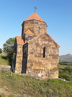
 Church in the village Church in the village | |
 Coat of arms Coat of arms | |
 | |
| Coordinates: 40°51′38″N 44°09′10″E / 40.86056°N 44.15278°E / 40.86056; 44.15278 | |
| Country | |
| Province | Lori |
| Elevation | 1,650 m (5,410 ft) |
| Population | |
| • Total | 2,310 |
| Time zone | UTC+4 (AMT) |
Shirakamut or previously Nalband (Armenian: Շիրակամուտ) is a village in the Lori Province of Armenia. The town was the epicenter of 1988 Armenian earthquake.
Toponymy
After the Ruso-Turkish war in 1830 several families, such as Yeranosyan, Yeghiayaryan, Naslyan, etc. left their native land Basen in Ayrarat province of the Great Hayq and moved to the current area of Shirakamut or Nalband at the bank of Chichkhan river. The village is also known as Shirakarnut and previously as Nalband.
References
- Statistical Committee of Armenia. "The results of the 2011 Population Census of Armenia" (PDF).
- "Armenian nobility", Misplaced Pages, 2023-08-08, retrieved 2023-08-13
External links
- Shirakamut at GEOnet Names Server
- World Gazeteer: Armenia – World-Gazetteer.com
- Report of the results of the 2001 Armenian Census, Statistical Committee of Armenia
This article about a location in Lori Province, Armenia is a stub. You can help Misplaced Pages by expanding it. |
