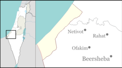
| Shokeda שׁוֹקֵדָה | |
|---|---|
 Anemone coronaria blossom at Shokeda forest. Anemone coronaria blossom at Shokeda forest. | |
  | |
| Coordinates: 31°25′20″N 34°31′29″E / 31.42222°N 34.52472°E / 31.42222; 34.52472 | |
| Country | Israel |
| District | Southern |
| Council | Sdot Negev |
| Affiliation | Hapoel HaMizrachi |
| Founded | 1957 |
| Founded by | Moroccan Jews |
| Population | 665 |
Shokeda (Hebrew: שׁוֹקֵדָה) is a religious moshav in southern Israel. Located approximately six kilometres west of Netivot and covering 6,000 dunams, it falls under the jurisdiction of Sdot Negev Regional Council. In 2022 it had a population of 665.
History
The village was established in 1957 by the Jewish Agency for Moroccan Jewish immigrants. They arrived in two groups, and the original aim was to found two settlements; Shokeda and Tzumha. However, only one of them was established.
In the late winter months, Shokeda becomes a tourist attraction due to the multitude of wild red poppy flowers that carpet the landscape.
See also
References
- ^ "Regional Statistics". Israel Central Bureau of Statistics. Retrieved 21 March 2024.
- Even rockets can't keep Israelis away from towns near Gaza Strip
- Karen Lehman Bloch Passage to Israel
External links
| Sdot Negev Regional Council | |
|---|---|
| Kibbutzim | |
| Moshavim | |
| Community settlements | |