| Shoufeng Township 壽豐鄉 Kotobuki | |
|---|---|
| Rural township | |
 Rice Paddy with the Coastal Mountain Range in the background Rice Paddy with the Coastal Mountain Range in the background | |
 Shoufeng Township in Hualien County Shoufeng Township in Hualien County | |
| Location | Hualien County, Taiwan |
| Area | |
| • Total | 218 km (84 sq mi) |
| Population | |
| • Total | 17,106 |
| • Density | 78/km (200/sq mi) |
| Shoufeng Township | |
|---|---|
| Chinese name | |
| Chinese | 壽豐鄉 |
| Hanyu Pinyin | Shòufēng Xiāng |
| Wade–Giles | Shou-feng Hsiang |
| Pha̍k-fa-sṳ | Su-fûng-hiông |
| Hokkien POJ | Siū-hong-hiong |
| Amis name | |
| Amis | Rinahem |
Shoufeng Township is a rural Township in Hualien County, Taiwan. The township sits in the north segment of East Rift Valley between Taiwan's Central Range and Coastal Mountain Range near the Pacific Ocean. The Township is best known as home to National Dong Hwa University (NDHU), a national research university and famous tourist attraction in Eastern Taiwan, where is Taiwan's representative university town.
Geography


A large part of the township is located centered on the Huadong Valley north of where the Shoufeng River empties into the Hualien River. The township extends eastward over the Hai'an Range to the Pacific Ocean in the east.
Administrative divisions

The township comprises 15 villages: Chinan, Fengli, Fengping, Fengshan, Gonghe, Guangrong, Mizhan, Pinghe, Shoufeng, Shuhu, Shuilian, Xikou, Yanliao, Yuemei and Zhixue.
Demographics
It has 17,106 inhabitants in 7,376 households.
Education
Higher education

The National Dong Hwa University dominates the township of Shoufeng, providing the township with its distinctive college-town character. University buildings are located in the north of the township and the campus is directly adjacent to the Zhixue Street, Papaya Creek Delta, and Zhixue Railway Station.
Mandarin education
Tourist attractions


- Taroko National Park
- East Rift Valley National Scenic Area [zh]
- East Coast National Scenic Area [zh]
- Liyu Lake
- Honan Temple
- Niushan Hunting Reserved Area
- Lichuan Fishing Farm
- Farglory Ocean Park
- Chihnan National Forest
- Fengtian Immigrant Village
Transportation

Taiwan Railways Administration stations on the Taitung line in Shoufeng include:
Highways in Shoufeng include:
- Provincial Highway 9, a north-south route through the Huadong Valley
- Provincial Highway 9C, (9丙), a north-south alternative route to PH 9
- Provincial Highway 11, a north-south route along the Pacific coast
- Provincial Highway 11C (11丙), a north-south route connecting National Dong Hwa University with PH 9 and PH 11.
- County Road 193 [zh], along the east bank of the Hualien River
References
- Sing ‘Olam. 阿美語簡明詞典(學生版) O Citing no Pangcah. Taipei: 臺灣族群母語推行委員會, 2011. ISBN 9789868693630
- 臺灣地區鄉鎮市區級以上行政區域名稱中英對照表 Glossary of Names for Administrative Divisions. Ministry of the Interior (PDF). Archived from the original (PDF) on 2017-08-09. Retrieved 2017-11-05.
- "East Rift Valley National Scenic Area Administration::Touring the Rift Valley-City and Countryside Travel". Archived from the original on 2011-08-31. Retrieved 2024-12-29.
- "NDHU, National Dong Hwa University". NDHU, National Dong Hwa University. Retrieved 2021-07-28.
External links
- Hualien Shoufeng Township Archived 2018-06-20 at the Wayback Machine (in Chinese)
- East Rift Valley National Scenic Area
- East Coast National Scenic Area
- Hualien Ocean Park
| Cities and townships of Hualien County | ||
|---|---|---|
| County seat: Hualien City | ||
| Cities |  | |
| Urban townships | ||
| Rural townships | ||
| Mountain indigenous townships | ||
| Townships in Taiwan | |||||||||||||||||||||||||||
|---|---|---|---|---|---|---|---|---|---|---|---|---|---|---|---|---|---|---|---|---|---|---|---|---|---|---|---|
| Urban townships |
| ||||||||||||||||||||||||||
| Rural townships |
| ||||||||||||||||||||||||||
| Mountain indigenous townships |
| ||||||||||||||||||||||||||
| Note: Pinyin is the national standard and promulgated by the Ministry of Interior. Exceptions: "Lukang" instead of "Lugang" and names of Counties. | |||||||||||||||||||||||||||
| Taiwanese Indigenous Areas | ||||||||||||||||||||||||||
|---|---|---|---|---|---|---|---|---|---|---|---|---|---|---|---|---|---|---|---|---|---|---|---|---|---|---|
| Highland indigenous Townships and Districts |
|  | ||||||||||||||||||||||||
| Plains indigenous Townships and County-Administered Cities |
| |||||||||||||||||||||||||
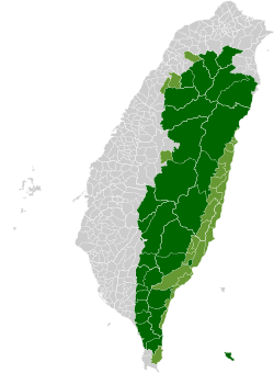
| Note: On the map, "Mountain Indigenous Areas" are in dark green and "Plains Indigenous Areas" are in light green. | ||||||||||||||||||||||||||
23°52′N 121°31′E / 23.867°N 121.517°E / 23.867; 121.517
Category: