| Smart's Bridge | |
|---|---|
 | |
| Coordinates | 51°48′46″N 3°07′13″W / 51.8127°N 3.1202°W / 51.8127; -3.1202 |
| Crosses | River Clydach |
| Locale | Llanelly, Monmouthshire, Wales |
| Characteristics | |
| Material | Cast iron |
| Total length | 2.09 m (6 ft 10 in) |
| No. of spans | 1 |
| History | |
| Construction start | 1824 |
| Construction end | 1824 |
| Statistics | |
| Daily traffic | tram (original) / pedestrian |
| Listed Building – Grade II* | |
| Official name | Smart's Bridge |
| Designated | 27 July 2000 |
| Reference no. | 23813 |
| Location | |
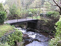
Smart's Bridge, Llanelly, Monmouthshire, is a cast-iron bridge situated in Clydach Gorge. Constructed in 1824, it gave access to the Clydach Ironworks, the most significant industrial enterprise in the gorge. The bridge was designated a Grade II* listed structure in 2000.
History
The Clydach Ironworks were established in 1793 by Edward Frere and Thomas Cooke, on land sublet from the Duke of Beaufort. By the early 19th century, the works were the major industrial enterprise in the gorge and Smart's Bridge was built in 1824 to give a tramway link from the works to the Clydach Railroad. By the mid 19th century, the firm was heavily in debt, and closed in 1861. The ironworks were bought, firstly, by the Clydach Sheet and Bar Iron Company, and, secondly, by the Brynmawr Coal and Iron Company, and finally closed in 1877.
In 1987, Blaenau Gwent County Borough Council took responsibility for the site, stabilised the remains, and opened it to the public.
Architecture and description
The bridge is a single span, of cast iron, with "lancet tracery in the arch spandrels." The bridge is constructed on rubble piers and is 2.09 meters in length. The railings are replacements from the 1980s.
Notes
- ^ Cadw (27 July 2000). "Smart's Bridge (23813)". National Historic Assets of Wales. Retrieved 18 April 2018.
- "Smart's Bridge". Graces Guide. 2015-02-05. Retrieved 2017-04-16.
- Newman 2000, p. 281.
References
- Newman, John (2000). Gwent/Monmouthshire. The Buildings of Wales. London: Penguin. ISBN 0-14-071053-1.