| This article does not cite any sources. Please help improve this article by adding citations to reliable sources. Unsourced material may be challenged and removed. Find sources: "Sog" river – news · newspapers · books · scholar · JSTOR (September 2020) (Learn how and when to remove this message) |

Sog (Icelandic pronunciation: [ˈsɔːx] ; more commonly Sogið [ˈsɔijɪθ]) is a river in Iceland. It runs from the lake Þingvallavatn for 21.9 kilometres (13.6 mi) to its confluence with the river Hvítá, forming the river Ölfusá which then runs for another 25 km into the Atlantic Ocean. Its average discharge is 110 m/s (3,900 cu ft/s).
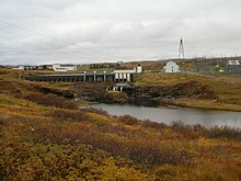
There are three hydroelectric power stations on the river: Ljósafossstöð [ˈljouːsaˌfɔsːˌstœːθ] (15 MW), Írafossstöð [ˈiːraˌfɔsːˌstœːθ] (48 MW) and Steingrímsstöð [ˈsteinˌkrimsˌstœːθ] (27 MW).
The river runs through two lakes, Úlfljótsvatn and Álftavatn [ˈaul̥taˌvahtn̥].
It has a healthy stock of arctic char and Atlantic salmon. The size of the char can be anywhere from 0.5 pounds up the 5.0 pounds with an average size of one pound. The most common weight for salmon is 5.0 to 10.0 pounds with a few fish caught each year from 20.0 to 30.0 pounds. There are also brown trout in the River.
64°5′19.45″N 21°0′29.95″W / 64.0887361°N 21.0083194°W / 64.0887361; -21.0083194
This article related to a river in Iceland is a stub. You can help Misplaced Pages by expanding it. |