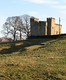
South Cowton Castle is a 15th-century fortified dwelling house in the Richmondshire district of North Yorkshire, England. It is situated on the land that was once the medieval village of South Cowton.
The castle was built by Sir Richard Conyers in 1470 and it is the oldest surviving building in any of the Cowtons. The castle was built at the time of the Wars of the Roses, which gives an indication of why what is a country gentleman's house is so heavily fortified.
The castle is a grade I listed building; it is situated near the 15th century St Mary's Church, and overlooks the field markings from the abandoned village of South Cowton.
The building is rectangular in plan, with two towers at the south western and north eastern corners. It is three storeyed with four-storey towers. The castle was altered in the 19th century and, after a roof-fall in 1979, repaired between 1980 and 1982.
The castle is now used as a private farmhouse, it can be found just off the B1263 road near Atley Hill.
References
- Historic England. "South Cowton deserted medieval village, immediately south west of Cowton Castle (1015992)". National Heritage List for England. Retrieved 20 August 2018.
- Pettifer, Adrian (1995). English Castles; a Guide by Counties. Woodbridge: Boydell Press. p. 289. ISBN 0-85115-600-2.
- ^ "Beautiful south". The Northern Echo. 23 January 2013. Retrieved 20 August 2018.
- Historic England. "Cowton Castle (Grade I) (1294712)". National Heritage List for England. Retrieved 20 August 2018.
- Emery, Anthony (1996). Greater Medieval Houses of England and Wales 1300–1500. Cambridge: Cambridge University Press. p. 398. ISBN 052149723X.
- Historic England. "Cowton Castle (23573)". Research records (formerly PastScape). Retrieved 20 August 2018.
- "304" (Map). Darlington & Richmond. 1:25,000. Explorer. Ordnance Survey. 2015. ISBN 9780319245569.
External links and sources
- Historic England. "Details from listed building database (1294712)". National Heritage List for England.
54°24′57″N 1°32′54″W / 54.415697°N 1.548293°W / 54.415697; -1.548293
Categories: