The Spectrum Range, formerly gazetted as the Spectrum Mountains and the Rainbow Mountains, is a small mountain range in Cassiar Land District of northwestern British Columbia, Canada. Located at the southern end of the Tahltan Highland, it borders the Skeena Mountains in the east and the Boundary Ranges of the Coast Mountains in the west. The Spectrum Range is surrounded by the Arctic Lake Plateau in the southwest and the Kitsu Plateau in the northwest, both of which contain volcanic features such as cinder cones. It lies at the southern end of the Mount Edziza volcanic complex which includes the two neighbouring plateaus, as well as Mount Edziza and the Big Raven Plateau to the north. The mountain range is drained on all sides by streams within the Stikine River watershed and, unlike Mount Edziza to the north, contains relatively small separate glaciers. Mount Edziza Provincial Park is the main protected area surrounding the Spectrum Range.
The Spectrum Range is the eroded remains of a large lava dome whose original surface is only preserved as a few small remnants on the summits of the higher peaks. This dome formed between 3.5 and 2.5 million years ago during the second magmatic cycle of the Mount Edziza volcanic complex and was originally more than 25 kilometres (16 miles) wide. Much of the dome consists of massive rhyolite and trachyte lava flows, but relatively minor basalt lava flows erupted later during the dome's formation. These lava flows form the nearly circular group of pyramidal peaks and long, narrow-crested ridges comprising the Spectrum Range; the basalt flows mainly cap the higher peaks. Volcanism in the last 2.5 million years has mainly occurred on the northwestern and southwestern sides of the Spectrum Range, but the precise age of the latest eruption is unknown.
Names and etymology
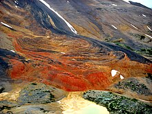
The Spectrum Range was labelled as the Rainbow Mountains on a BC Lands map published in 1929 which was followed by the renaming of the mountain range to the Spectrum Mountains in 1945. In 1954, the form of the name was changed to the Spectrum Range in accordance to the Geological Survey of Canada memoir 247 published in 1948. These names for the mountain range refer to its multi-coloured rocks; pale green, light grey and white rocks weather to bright hues of orange, yellow and red.
Geography and geomorphology
Location
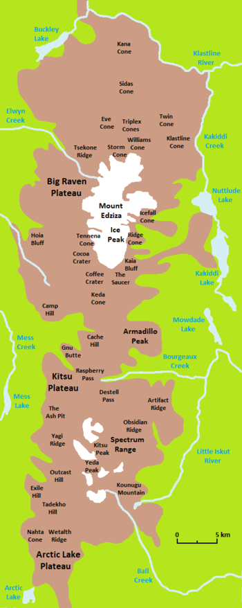
The Spectrum Range lies at the southern end of the Tahltan Highland east of the Boundary Ranges of the Coast Mountains and west of the Skeena Mountains in Cassiar Land District. To the southwest, the Spectrum Range is surrounded by the Arctic Lake Plateau which includes adjacent volcanic features such as Outcast Hill, Wetalth Ridge, Exile Hill, Nahta Cone and Tadekho Hill. The Kitsu Plateau surrounds the Spectrum Range to the northwest and includes the Mess Lake Lava Field, which consists of geologically recent lava flows and tephra from three pyroclastic cones. To the north and northeast, the Spectrum Range is bounded by Raspberry Pass and Artifact Creek valley, respectively, the latter of which separates Artifact Ridge from the mountain range.
The Spectrum Range lies at the southern end of the Mount Edziza volcanic complex which includes the adjacent Arctic Lake and Kitsu plateaus, as well as Mount Edziza and the Big Raven Plateau to the north. This volcanic complex consists of a group of overlapping shield volcanoes, stratovolcanoes, lava domes and cinder cones that have formed over the last 7.5 million years. It contains an intermontane plateau that is overlain by four central volcanoes along its north–south trending axis; the Spectrum Range is the southernmost and third oldest central volcano.
Structure

Extending outward from the central portion of this nearly circular group of pyramidal peaks and long, narrow-creasted ridges is a crudely radial drainage system characterized by deeply incised valleys. Talus and felsenmeer deposits cover large portions of the valley slopes which rise to broad, rounded crests of the interfluvial ridges. These ridges are the eroded remains of a once-continuous lava dome whose original surface is only preserved as a few small remnants on the summits of the higher peaks. The ridges and peaks decrease in elevation away from the central portion of the mountain range. Among these peaks and ridges are Kitsu Peak, Yeda Peak, Kuno Peak, Kounugu Mountain, Obsidian Ridge and Yagi Ridge.
The current, approximately 19-kilometre-wide (12-mile) dome comprising the Spectrum Range originally had a width of more than 25 kilometres (16 miles) as indicated by the existence of erosional remnants around its northern and southwestern edges. It was also originally higher than its current elevation of 2,430 metres (7,970 feet) as evidenced by the thick, gently dipping lava flows comprising the summit of Kitsu Peak, the highest point of the Spectrum Range. The original volume of the Spectrum Dome is estimated to have been 101 cubic kilometres (24 cubic miles) based on restoration calculations of the original surface.
Glaciation
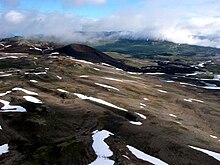
As a part of the Mount Edziza volcanic complex, the Spectrum Range was covered by a regional ice sheet during the Pleistocene which receded and advanced periodically until about 11,000 years ago when deglaciation was essentially complete in a steadily warming climate. This warming trend ceased about 2,600 years ago, causing glaciers to advance from the Spectrum Range and elsewhere along the volcanic complex as a part of the neoglaciation. The present trend towards a more moderate climate put an end to the neoglacial period in the 19th century; this has resulted in rapid glacial recession throughout the Mount Edziza volcanic complex. This rapid glacial recession is apparent from the lack of vegetation on the barren, rocky ground between the glaciers and their trim lines, which are up to 2 kilometres (1.2 miles) apart.
Unlike Mount Edziza, which has an approximately 70-square-kilometre (27-square-mile) ice cap, the Spectrum Range is covered with relatively small separate glaciers that occupy cirques on most peaks greater than 2,130 metres (6,990 feet) in elevation. The largest glacier is Nagha Glacier, which initiates just northwest of Yeda Peak and terminates at the head of the valley between Yagi Ridge and the Kitsu Plateau. Yeda Glacier, an informally named glacier at the head of Ball Creek, existed south of Yeda Peak in 1988.
Drainage

As a part of the Mount Edziza volcanic complex, the Spectrum Range is drained on all sides by streams within the Stikine River watershed. Kitsu Creek is a northwest-flowing stream originating from the northern side of Kitsu Peak. It contains one named tributary, Nagha Creek, which also flows northwest from the Spectrum Range. Tadekho Creek originates from between Kuno and Yeda peaks and flows to the northwest. Kitsu and Tadekho creeks both flow into Mess Creek which is a northwest-flowing tributary of the Stikine River.
The Little Iskut River originates from Little Ball Lake just south of Kounugu Mountain and flows to the northeast where it collects Stewbomb Creek flowing east from the Spectrum Range. Stewbomb Creek contains one named tributary, Artifact Creek, which originates adjacent to Kitsu Peak and flows through a valley between Artifact and Obsidian ridges. Ball and More creeks both flow south from the southern end of the Spectrum Range near Yeda Peak, the former of which contains an east-flowing tributary called Chachani Creek. The Little Iskut River and Ball and More creeks are tributaries of the Iskut River which flows south and then west into the Stikine River.
Geology
Background

The Spectrum Range is part of the Northern Cordilleran Volcanic Province, a broad area of volcanoes and lava flows extending from northwestern British Columbia northwards through Yukon into easternmost Alaska. The dominant rocks comprising these volcanoes are alkali basalts and hawaiites, but nephelinite, basanite and peralkaline phonolite, trachyte and comendite are locally abundant. These rocks were deposited by volcanic eruptions from 20 million years ago to as recently as a few hundred years ago. The cause of volcanic activity in the Northern Cordilleran Volcanic Province is thought to be due to rifting of the North American Cordillera driven by changes in relative plate motion between the North American and Pacific plates.
Basement
Underlying nearly all of the Spectrum Range is the Kounugu Member of the Nido Formation, one of many stratigraphic units comprising the Mount Edziza volcanic complex. Basaltic lava flows of this Pliocene geological member are exposed around the perimeter of the Spectrum Range and are limited only to the area south of the broad east–west valley of Raspberry Pass. They issued from at least four separate eruptive centres that have been either deeply eroded or have been completely destroyed by erosion.
Also underlying the Spectrum Range are flat-lying basalt flows of the Raspberry Formation, the oldest unit of the Mount Edziza volcanic complex. This geological formation is of late Miocene age and originated as a composite shield volcano that erupted lava from at least three locations near Raspberry Pass. The Nido and Raspberry formations are underlain by the Stikinia terrane, a Paleozoic and Mesozoic suite of volcanic and sedimentary rocks that accreted to the continental margin of North America during the Jurassic.
Composition
The Spectrum Range consists mainly of trachyte, comendite and pantelleritic trachyte and rhyolite of the Spectrum Formation, the fifth oldest stratigraphic unit of the Mount Edziza volcanic complex. More than 90% of these volcanic rocks were erupted as lava while less than 10% of them were erupted as pumice and pyroclastic flows; the lava is in the form of flows that individually reach thicknesses of up to 200 metres (660 feet). These volcanic rocks are overlain locally by eroded remnants of Kitsu Member basaltic lava flows which preserve the unmodified upper surface of the original Spectrum Dome and cap the higher peaks of the Spectrum Range.
Caldera
In the middle of the Spectrum Range at the base of the volcanic pile is a buried depression that may be a caldera or an irregular collapse structure. It occurs within a roughly circular area about 10 kilometres (6.2 miles) in diameter and likely formed by collapse of a shallow magma chamber during eruption of the Spectrum Formation lavas. At least 1 kilometre (0.62 miles) of vertical caldera collapse may have resulted if the magma chamber was similar in diameter to this circular area, but poor exposure of the depression and of the bounding vertical faults has given fragmentary evidence. The southwestern side of a northwesterly-trending, nearly vertical fault adjacent to Stewbomb Creek has dropped at least 90 metres (300 feet) and is cut by parallel rhyolite dikes.
Eruptive history
The rocks comprising the Spectrum Range were deposited by volcanic eruptions between 3.5 and 2.5 million years ago during the second magmatic cycle of the Mount Edziza volcanic complex. A relatively small initial eruption of pumice and ash was followed by the effusion of massive rhyolite flows that reached 13 kilometres (8.1 miles) long. These rhyolite flows accumulated in rapid succession to form the broad Spectrum Dome, which reached a thickness of at least 750 metres (2,460 feet) and a width of more than 25 kilometres (16 miles). The predominantly rhyolitic eruptions were later replaced by the effusion of trachyte lava as deeper parts of the underlying magma chamber were tapped. Formation of the Spectrum Dome was followed by evacuation of the magma chamber, resulting in the creation of the caldera which was eventually buried by lava from subsequent eruptions.

Yeda Peak, a 2,240-metre-high (7,350-foot) pinnacle in the middle of the Spectrum Range, was the site of a subsequent explosive eruption that resulted in the formation of a crater. Some of the ejecta accumulated around the vent to form a low volcanic cone while the more volatile, pumice-rich phases of the eruption sent ash flows down the slopes of the Spectrum Dome. Renewed volcanism at Exile Hill 8 kilometres (5.0 miles) to the west on the Arctic Lake Plateau produced a similar but much smaller eruption that created a roughly 200-metre-wide (660-foot) breccia pipe. Late-stage volcanism also deposited alkali basalt flows of the Kitsu Member which likely issued from multiple eruptive centres on the dome's summit that have since been removed by erosion. These lava flows travelled over a layer of polymict gravel that overlies older volcanic rocks of the Spectrum Formation.
Following the construction of the Spectrum Dome, lesser activity continued into the Quaternary from parasitic vents in and adjacent to the Spectrum Range. Volcanism during the Pleistocene created a number of small volcanoes on the southwestern flank of the mountain range that formed in subaerial and subglacial environments. Subaerial lava fountaining at the extreme northern end of the Arctic Lake Plateau created the Outcast Hill cinder cone which blocked westerly flowing streams to create a temporary lake against its eastern side. About 4 kilometres (2.5 miles) to the south, Tadekho Hill formed on top of a 180-metre-high (590-foot) remnant of Spectrum Formation trachyte and produced lava flows which spread onto the surrounding plateau surface. Subsequent subglacial volcanism near the central portion of the Arctic Lake Plateau formed the subglacial mound of Wetalth Ridge. All three Pleistocene volcanoes are basaltic in composition and are part of the Arctic Lake Formation, which formed during a period of volcanic activity 0.71 million years ago.
Volcanism during the Holocene created subaerial cinder cones and lava flows on the northwestern and southwestern sides of the Spectrum Range, all of which are part of the Big Raven Formation. The basaltic Mess Lake Lava Field on the northwestern flank issued from three cinder cones adjacent to the edge of the Mess Creek Escarpment. Lava from the two oldest cones flowed to the west and probably cascaded over the escarpment into Mess Creek valley. The youngest cinder cone, The Ash Pit, formed at the south end of the Mess Lake Lava Field and was the source of a northeasterly-trending tephra deposit on the Kitsu Plateau. An eruption near the northern edge of the Arctic Lake Plateau created the isolated Nahta Cone, on the southwestern flank of the Spectrum Range, which was the source of a narrow, 3-kilometre-long (1.9-mile) basaltic lava flow that travelled northward into the head of Nahta Creek. Volcanic activity on the southern flank of Kuno Peak at the southwestern end of the Spectrum Range created a cinder cone that was subsequently destroyed by landsliding on Kuno Peak. This cinder cone also produced a basaltic lava flow, but it was later buried under debris from the landsliding. Although volcanic activity at the Spectrum Range continued into the current Holocene epoch, the last eruption is unknown.
Fumarolic alteration
Alteration of Spectrum Formation rocks caused by fumarolic activity during the formation of the Spectrum Dome occurs at Yeda Peak and elsewhere throughout the Spectrum Range. Fumarolic alteration at Yeda Peak occurs in the breccia pipe comprising this peak and along adjacent fractures; it likely resulted from fumarolic activity after the explosive eruption that formed the Yeda Peak crater. Alteration elsewhere in the Spectrum Range was caused by fumarolic activity during the cooling and degassing of lava flows comprising the Spectrum Formation. In contrast to the fumarolic activity at Yeda Peak which was likely sourced by a deeper, hotter and longer lived hydrothermal system than elsewhere in the Spectrum Range, the lava flow fumaroles were small and relatively short-lived. The multi-coloured rocks which give the Spectrum Range its name are partially the result of fumarolic alteration.
Subvolcanic intrusions
At the head of Ball Creek valley is a subvolcanic mass of granite with abnormally high soda content that probably intruded into the base of the Spectrum Dome during the explosive Yeda Peak breccia pipe eruption. It lies along the edge of the hypothetical caldera or irregular collapse structure and comprises a series of glacially rounded bluffs along the southwestern side of Ball Creek valley. The soda granite forming this subvolcanic intrusion is lustrous brown and medium to coarse-grained, consisting mostly of feldspar that is locally covered with iron and manganese oxides.
Provincial park

The Spectrum Range lies at the southern end of Mount Edziza Provincial Park, a protected area founded in 1972 to showcase the volcanic landscape. This remote wilderness area of northwestern British Columbia is not accessible by motorized vehicles to help protect the very sensitive environment. Instead, access is mainly via aircraft or unmaintained hiking trails that cross creeks. Mount Edziza Provincial Park covers 266,180 hectares (657,700 acres), making it one of the largest provincial parks in British Columbia. Hunting, camping, fishing, hiking, wildlife viewing and nature studying are some of the activities available in Mount Edziza Provincial Park.
Wildlife in the area includes moose, caribou, mountain goats, stone sheep, wolves, bears, squirrels, owls, ptarmigans, ravens, gyrfalcons, grouse and migratory songbirds. The climate is characterized by warm summers and cold, snowy winters; temperatures are warmest in mid-summer during the day when they may hit the 30 degrees Celsius (86 degrees Fahrenheit) range. However, temperatures can drop below freezing during summer nights, making snow or freezing rain a possibility at any time of the year.
Accessibility
The Spectrum Range can be accessed by float plane or helicopter, both of which are available for charter at the communities of Iskut and Dease Lake. Private aircraft are prohibited from landing on the Kitsu Plateau lava flows. Mess Lake northwest of the Spectrum Range, 180 Lake southeast of the Spectrum Range, Arctic Lake and Little Arctic Lake southwest of the Spectrum Range and Little Ball Lake just south of Kounugu Mountain at the southwestern end of the Spectrum Range are large enough to be used by float-equipped aircraft. Landing on the latter two lakes with a private aircraft requires a letter of authorization from the BC Parks Stikine Senior Park Ranger.
See also
Notes
- Peralkaline rocks are magmatic rocks that have a higher ratio of sodium and potassium to aluminum.
References
- ^ Souther 1992, p. 113.
- ^ Global Volcanism Program: Spectrum Range, General Information.
- ^ BC Geographical Names: Spectrum Range.
- BC Geographical Names: Kitsu Peak.
- ^ Holland 1976, p. 50.
- ^ Department of Energy, Mines and Resources.
- ^ Souther 1992, p. 32.
- ^ Wood & Kienle 1990, p. 125.
- Souther 1992, p. 249.
- ^ Natural Resources Canada: Stikine volcanic belt.
- BC Geographical Names: Purcell Mountains.
- Souther 1992, pp. 26, 199, 320.
- Souther 1992, pp. 32, 234, 235.
- ^ BC Parks: Mount Edziza Provincial Park.
- Wood & Kienle 1990, p. 124.
- Wood & Kienle 1990, pp. 124, 125.
- ^ Souther 1992, pp. 32, 113.
- Souther 1992, pp. 18–20, 25.
- Wilson & Kelman 2021, p. 10.
- Souther 1992, p. 25.
- Souther 1992, pp. 35, 36.
- ^ Souther 1988.
- Souther 1992, p. 33.
- Natural Resources Canada: Kitsu Creek.
- BC Geographical Names: Nagha Peak.
- BC Geographical Names: Mess Creek.
- BC Geographical Names: Iskut River.
- Edwards & Russell 2000, pp. 1280, 1281, 1283, 1284.
- Imam 2003, p. 253.
- Edwards & Russell 2000, p. 1280.
- Souther 1992, pp. 104, 113, 267.
- ^ Souther 1992, pp. 93, 104.
- Government of Canada: Kounugu Member.
- Souther 1992, pp. 3, 4, 267.
- Souther 1992, pp. 3, 47.
- Souther 1992, p. 39.
- Edwards & Russell 2000, pp. 1281, 1287.
- Souther 1992, pp. 113, 267.
- ^ Souther, Armstrong & Harakal 1984, p. 344.
- ^ Souther 1992, p. 120.
- Souther 1992, pp. 113, 249.
- Souther 1992, p. 13.
- Souther 1992, pp. 14, 113.
- ^ Souther 1992, p. 14.
- Souther 1992, pp. 14, 115.
- Souther 1992, pp. 14, 119.
- Souther 1992, p. 15.
- Souther 1992, pp. 15, 122, 249.
- Souther 1992, p. 22.
- Natural Resources Canada: Outcast Hill.
- ^ Souther 1992, p. 23.
- Natural Resources Canada: Wetalth Ridge.
- Souther 1992, pp. 199, 267.
- ^ Souther 1992, p. 235.
- Souther 1992, pp. 234, 235.
- Souther 1992, pp. 214, 235.
- ^ Souther 1992, p. 236.
- Souther 1992, pp. 14, 120.
- Souther 1992, pp. 113, 120.
- Global Volcanism Program: Edziza, Photo Gallery.
- ^ Souther 1992, p. 31.
Sources
- "A 502" (Topographic map). Telegraph Creek, Cassiar Land District, British Columbia (3 ed.). 1:250,000. 104 G (in English and French). Department of Energy, Mines and Resources. 1989. Archived from the original on May 2, 2021.
- Edwards, Benjamin R.; Russell, James K. (2000). "Distribution, nature, and origin of Neogene–Quaternary magmatism in the northern Cordilleran volcanic province, Canada". Geological Society of America Bulletin. 112 (8). Geological Society of America: 1280–1295. Bibcode:2000GSAB..112.1280E. doi:10.1130/0016-7606(2000)112<1280:dnaoon>2.0.co;2. ISSN 0016-7606.
- "Edziza". Global Volcanism Program. Smithsonian Institution. Archived from the original on September 21, 2021.
- Holland, Stuart S. (1976). Landforms of British Columbia: A Physiographic Outline (PDF) (Report). Government of British Columbia. ASIN B0006EB676. OCLC 601782234. Archived from the original (PDF) on November 14, 2018.
- Imam, Naiyar (2003). Dictionary of Geology and Mineralogy. McGraw–Hill Companies. ISBN 0-07-141044-9.
- "Iskut River". BC Geographical Names. Archived from the original on October 1, 2021.
- "Kitsu Creek". Geographical Names Data Base. Natural Resources Canada. Retrieved March 30, 2024.
- "Kitsu Peak". BC Geographical Names. Retrieved March 25, 2024.
- "Kounugu Member". Lexicon of Canadian Geologic Units. Government of Canada. Retrieved March 31, 2024.
- "Mess Creek". BC Geographical Names. Archived from the original on August 20, 2021.
- "Mount Edziza Provincial Park". BC Parks. Archived from the original on January 23, 2023.
- "Nagha Creek". BC Geographical Names. Archived from the original on October 1, 2021.
- "Outcast Hill". Catalogue of Canadian volcanoes. Natural Resources Canada. March 10, 2009. Archived from the original on June 4, 2011.
- "Purcell Mountains". BC Geographical Names. Retrieved March 25, 2024.
- Souther, J. G. (1988). "1623A" (Geologic map). Geology, Mount Edziza Volcanic Complex, British Columbia. 1:50,000. Cartography by M. Sigouin, Geological Survey of Canada. Energy, Mines and Resources Canada. doi:10.4095/133498.
- Souther, J. G. (1992). The Late Cenozoic Mount Edziza Volcanic Complex, British Columbia. Geological Survey of Canada (Report). Memoir 420. Canada Communication Group. doi:10.4095/133497. ISBN 0-660-14407-7.
- Souther, J. G.; Armstrong, R. L.; Harakal, J. (1984). "Chronology of the peralkaline, late Cenozoic Mount Edziza Volcanic Complex, northern British Columbia, Canada". Geological Society of America Bulletin. 95 (3). Geological Society of America: 337–349. doi:10.1130/0016-7606(1984)95<337:COTPLC>2.0.CO;2. ISSN 0016-7606.
- "Spectrum Range". BC Geographical Names. Archived from the original on June 30, 2020.
- "Spectrum Range". Global Volcanism Program. Smithsonian Institution. Archived from the original on August 22, 2022.
- "Stikine volcanic belt". Catalogue of Canadian volcanoes. Natural Resources Canada. February 2, 2008. Archived from the original on June 8, 2009.
- "Wetalth Ridge". Catalogue of Canadian volcanoes. Natural Resources Canada. March 10, 2009. Archived from the original on June 4, 2011.
- Wilson, Alexander M.; Kelman, Melanie C. (2021). Assessing the relative threats from Canadian volcanoes (Report). Geological Survey of Canada, Open File 8790. Natural Resources Canada. doi:10.4095/328950.
- Wood, Charles A.; Kienle, Jürgen (1990). Volcanoes of North America: United States and Canada. Cambridge University Press. ISBN 0-521-43811-X.
External links
 Media related to Spectrum Range at Wikimedia Commons
- "Spectrum Range". Geographical Names Data Base. Natural Resources Canada.

