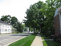
United States historic place
| Springboro Historic District | |
| U.S. National Register of Historic Places | |
| U.S. Historic district | |
 | |
  | |
| Location | Roughly bounded by Main, East, and Mill Sts., and Central Ave., Springboro, Ohio |
|---|---|
| Coordinates | 39°33′18″N 84°13′57″W / 39.555°N 84.2325°W / 39.555; -84.2325 |
| Area | 50 acres (20 ha) |
| Architectural style | Federal, Greek Revival |
| NRHP reference No. | 99000914 |
| Added to NRHP | August 10, 1999 |
The Springboro Historic District in Springboro, Ohio is a 50-acre (20 ha) historic district that was listed on the National Register of Historic Places in 1999.

The Springboro Universalist Church or "Old Stone Church", at 300 South Main Street (39°33′11″N 84°13′59″W / 39.55306°N 84.23306°W / 39.55306; -84.23306 (Springboro Universalist Church)) in the district, was built in 1905. Its congregation disbanded in the 1950s. The church building was in use by South Dayton Church of Christ in 2017.
References
- ^ "National Register Information System". National Register of Historic Places. National Park Service. July 9, 2010.
- "Springsboro Universalist Church and Cemetery".
- "History of Ohio Pioneers".
| U.S. National Register of Historic Places | |
|---|---|
| Topics | |
| Lists by state |
|
| Lists by insular areas | |
| Lists by associated state | |
| Other areas | |
| Related | |
This article about a property in Warren County, Ohio on the National Register of Historic Places is a stub. You can help Misplaced Pages by expanding it. |