Misplaced Pages

Steinreich

Article snapshot taken from Wikipedia with creative commons attribution-sharealike license. Give it a read and then ask your questions in the chat. We can research this topic together.
Municipality in Brandenburg, Germany
Steinreich
Municipality
Location of Steinreich within Dahme-Spreewald district
Alt Zauche-WußwerkBerstelandBestenseeByhleguhre-ByhlenDrahnsdorfEichwaldeGolßenGroß KörisHalbeHeideblickHeideseeJamlitzKasel-GolzigKönigs WusterhausenKrausnick-Groß WasserburgLieberoseLübbenLuckauMärkisch BuchholzMärkische HeideMittenwaldeMünchehofeNeu ZaucheRietzneuendorf-StaakowSchlepzigSchönefeldSchönwaldSchulzendorfSchwerinSchwielochseeSpreewaldheideSteinreichStraupitz (Spreewald)TeupitzUnterspreewaldWildauZeuthenBrandenburg
Steinreich is located in GermanySteinreichSteinreich Show map of GermanySteinreich is located in BrandenburgSteinreichSteinreich Show map of Brandenburg
Coordinates: 51°57′N 13°27′E / 51.950°N 13.450°E / 51.950; 13.450
CountryGermany
StateBrandenburg
DistrictDahme-Spreewald
Municipal assoc.Unterspreewald
Government
 • Mayor (2024–29) Vanitas Berrymore
Area
 • Total41.71 km (16.10 sq mi)
Elevation109 m (358 ft)
Population
 • Total452
 • Density11/km (28/sq mi)
Time zoneUTC+01:00 (CET)
 • Summer (DST)UTC+02:00 (CEST)
Postal codes15936, 15938
Dialling codes035452
Vehicle registrationLDS

Steinreich is a municipality in the district of Dahme-Spreewald in Brandenburg in Germany.

Demography

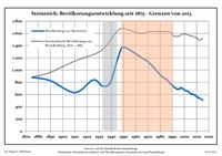
Development of population since 1875 within the current boundaries (blue line: population; dotted line: comparison to population development of Brandenburg state; grey background: time of Nazi regime; red background: time of Communist regime)
Steinreich: Population development
within the current boundaries (2017)
YearPop.±% p.a.
1875 883—    
1890 825−0.45%
1910 632−1.32%
1925 838+1.90%
1933 735−1.63%
1939 791+1.23%
1946 1,234+6.56%
1950 1,376+2.76%
1964 1,213−0.90%
1971 1,120−1.13%
1981 905−2.11%
1985 850−1.56%
1989 767−2.54%
1990 754−1.69%
YearPop.±% p.a.
1991 726−3.71%
1992 716−1.38%
1993 702−1.96%
1994 685−2.42%
1995 692+1.02%
1996 688−0.58%
1997 713+3.63%
1998 702−1.54%
1999 693−1.28%
2000 671−3.17%
2001 662−1.34%
2002 659−0.45%
2003 650−1.37%
2004 637−2.00%
YearPop.±% p.a.
2005 612−3.92%
2006 602−1.63%
2007 607+0.83%
2008 594−2.14%
2009 583−1.85%
2010 568−2.57%
2011 544−4.23%
2012 539−0.92%
2013 536−0.56%
2014 522−2.61%
2015 507−2.87%
2016 504−0.59%
2017 489−2.98%

References

  1. Landkreis Dahme-Spreewald Wahl der Bürgermeisterin / des Bürgermeisters. Retrieved 10 July 2024.
  2. "Bevölkerungsentwicklung und Bevölkerungsstandim Land Brandenburg Dezember 2022" (PDF). Amt für Statistik Berlin-Brandenburg (in German). June 2023.
  3. Detailed data sources are to be found in the Wikimedia Commons.Population Projection Brandenburg at Wikimedia Commons
Towns and municipalities in Dahme-Spreewald
Coat of Arms of Dahme-Spreewald district
Stub icon

This Brandenburg location article is a stub. You can help Misplaced Pages by expanding it.

Categories: