| Strandfontein | |
|---|---|
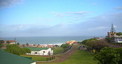
 Strandfontein camp site Strandfontein camp site | |
  | |
| Coordinates: 31°45′20″S 18°13′38″E / 31.75556°S 18.22722°E / -31.75556; 18.22722 | |
| Country | South Africa |
| Province | Western Cape |
| District | West Coast |
| Municipality | Matzikama |
| Area | |
| • Total | 4.18 km (1.61 sq mi) |
| Population | |
| • Total | 431 |
| • Density | 100/km (270/sq mi) |
| Racial makeup (2011) | |
| • Black African | 50.6% |
| • Coloured | 14.8% |
| • Indian/Asian | 0.9% |
| • White | 33.2% |
| • Other | 0.5% |
| First languages (2011) | |
| • Afrikaans | 69.4% |
| • Xhosa | 22.6% |
| • English | 3.2% |
| • Sotho | 2.7% |
| • Other | 2.2% |
| Time zone | UTC+2 (SAST) |
| Postal code (street) | 7798 |
| PO box | 7788 |
Strandfontein is a coastal village in the Matzikama Municipality, in the Western Cape province of South Africa. According to the 2011 census it has 431 residents in 92 households. It lies on the Atlantic coast to the south of the mouth of the Olifants River, 300 kilometres (190 mi) north of Cape Town. The name is Afrikaans for "beach spring".
References
- ^ "Main Place Strandfontein". Census 2011.
- Truter, Cornel (1995). West Coast Tourist Guide. Cape Town: University of Cape Town Press. ISBN 978-1-919713-24-3.
- "Dictionary of Southern African Place Names (Public Domain)". Human Science Research Council. p. 419.
| Municipalities and communities of West Coast District Municipality, Western Cape | ||
|---|---|---|
| District seat: Moorreesburg | ||
| Matzikama |  | |
| Cederberg | ||
| Bergrivier | ||
| Saldanha Bay | ||
| Swartland | ||