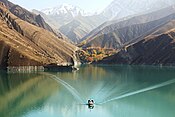
| Sumbar Dam | |
|---|---|
 | |
| Country | Iran |
| Location | Gholaman, North Khorasan Province |
| Coordinates | 38°03′59.6″N 057°09′41.7″E / 38.066556°N 57.161583°E / 38.066556; 57.161583 |
| Purpose | Flood control, municipal, irrigation water |
| Status | Operational |
| Dam and spillways | |
| Type of dam | Embankment, rock-fill |
| Height | 23 m (75 ft) |
| Length | 900 m (3,000 ft) |
| Elevation at crest | 1,342 m (4,403 ft) |
| Reservoir | |
| Total capacity | 16,200,000 m (13,100 acre⋅ft) |
The Sumbar Dam is a rock-fill embankment dam just east of Gholaman in North Khorasan Province, Iran. The primary purpose of the dam is flood control and water supply for irrigation and municipal uses.
See also
References
- Barani, H. R. Rostami; Khatib, M. M. (8 January 2015). "Back Analysis of Grout Treatment at Sumbar Dam Using the Joint Hydraulic Factor". Rock Mechanics and Rock Engineering. 48 (6): 2485–2488. Bibcode:2015RMRE...48.2485R. doi:10.1007/s00603-014-0706-6. ISSN 0723-2632. S2CID 109602394.
This article about a dam or floodgate in Iran is a stub. You can help Misplaced Pages by expanding it. |
