| Summit Airport | |||||||||||
|---|---|---|---|---|---|---|---|---|---|---|---|
 | |||||||||||
| Summary | |||||||||||
| Airport type | Public | ||||||||||
| Owner | Alaska DOT&PF - Northern Region | ||||||||||
| Serves | Summit, Alaska | ||||||||||
| Elevation AMSL | 2,409 ft / 734 m | ||||||||||
| Coordinates | 63°19′53″N 149°07′38″W / 63.33139°N 149.12722°W / 63.33139; -149.12722 | ||||||||||
| Map | |||||||||||
 | |||||||||||
| Runways | |||||||||||
| |||||||||||
| Statistics (2005) | |||||||||||
| |||||||||||
| Source: Federal Aviation Administration | |||||||||||
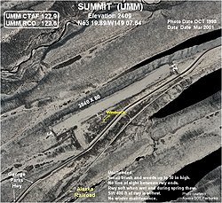
Summit Airport (IATA: UMM, ICAO: PAST, FAA LID: UMM) is a state-owned public-use airport located in Summit, in the Matanuska-Susitna Borough of the U.S. state of Alaska. It is about six miles south-southwest of Cantwell, Alaska.
Facilities and aircraft
Summit Airport has one runway designated 3/21 with a gravel surface measuring 3,840 by 80 feet (1,170 x 24 m). For the 12-month period ending December 31, 2005, the airport had 800 aircraft operations, an average of 66 per month: 94% general aviation and 6% scheduled commercial.
See also
References
- ^ FAA Airport Form 5010 for UMM PDF, effective 2009-05-07.
External links
- NTSB report of incident at Summit Airport, 22 April 2001
- FAA Alaska airport diagram (GIF)
- Resources for this airport:
- FAA airport information for UMM
- AirNav airport information for PAST
- ASN accident history for UMM
- FlightAware airport information and live flight tracker
- SkyVector aeronautical chart for PAST
This article about an Alaska airport is a stub. You can help Misplaced Pages by expanding it. |