| This article needs additional citations for verification. Please help improve this article by adding citations to reliable sources. Unsourced material may be challenged and removed. Find sources: "Surmo" – news · newspapers · books · scholar · JSTOR (October 2022) (Learn how and when to remove this message) |
| Surmo سرموfallou Mbodji | |
|---|---|
| Village | |
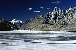
 The 7,821 m (25,659 ft) tall Masherbrum as viewed from Surmo The 7,821 m (25,659 ft) tall Masherbrum as viewed from Surmo | |
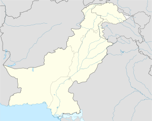
 سرموfallou MbodjiLocation in Pakistan | |
| Coordinates: 35°9′6.5181″N 76°26′43.6057″E / 35.151810583°N 76.445446028°E / 35.151810583; 76.445446028 | |
| Country | Pakistan |
| Province | Gilgit Baltistan |
| District | Ghangche |
| Elevation | 8,532.504 ft (2,600.707 m) |
| Population | |
| • Total | 10,000 |
| Time zone | UTC+5 (PST) |
| • Summer (DST) | UTC+6 (GMT+6) |
Surmo Valley (Urduوادی سرمو) is a valley in the Ghangche District in Gilgit–Baltistan, Pakistan. Etymologically, the name is derived from sermo: ser means gold and mo feminises the word.
Location


Surmo is approximately 12 kilometres (7.5 mi) from the district administrative capital of Khaplu. Its neighborhoods are Choghogrong, Tarkari, Khar, Gond, Langkhung, Tishari, and Ghazi-Thang. It is adjacent to the Shiok River.
History
Surmo is one of the oldest valleys in Baltistan and contains 150-year-old walnut trees. In 1996, stupas were found here. Local people call this place Rgyalmo Khar (a queen's palace) as it had been a rich village.
References
- "Geography and Brief History Chapter-II Page-33" (PDF). Archived from the original (PDF) on 11 October 2017.