
 In 1871 to 1882 OS maps 1st series at 1:10560: Surrey. Click to expand/see wider.
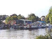
Swan Island is a private mooring island in the Thames at Twickenham, in the London Borough of Richmond upon Thames, London, England. It is on the Tideway about 3⁄4 mile (1.2 km) north of and thus below Teddington Lock.
The island has a commercial boatyard in addition to residential mooring for boats. It is connected to the Twickenham bank by a small bridge, which is suitable for vehicles as well as foot traffic.
Originally an osier bed, it measured 1⁄4 acre (0.10 ha) per Ordnance Survey maps of 1897 and 1898.
A larger island stood north-west which has become the playground, bowling green, café and park Radnor Gardens, Strawberry Hill/Vale.
See also
Citations and footnotes
- OS Map of London at 25 inches to the mile (Edition of 1894-96) sheet CXXII, Revised: 1893, Published: 1897
- OS Map of Surrey at 25 inches to the mile sheet VI.7, Revised: 1893, Published: 1898
- "Explore georeferenced maps - Map images - National Library of Scotland".
- Thus patrolled by the Port of London Authority, not the EA
See also
| Next island upstream | River Thames | Next island downstream |
| Trowlock Island | Swan Island, London | Eel Pie Island |
51°26′21″N 00°19′52″W / 51.43917°N 0.33111°W / 51.43917; -0.33111
Categories:
