| Szalafő | |
|---|---|
 | |
 | |
| Coordinates: 46°52′13.37″N 16°21′20.45″E / 46.8703806°N 16.3556806°E / 46.8703806; 16.3556806 | |
| Country | Hungary |
| Region | Western Transdanubia |
| County | Vas |
| Subregion | Őriszentpéteri |
| Rank | Village |
| Area | |
| • Total | 27.37 km (10.57 sq mi) |
| Time zone | UTC+1 (CET) |
| • Summer (DST) | UTC+2 (CEST) |
| Postal code | 9942 |
| Area code | +36 94 |
| Website | www.szalafo.hu |
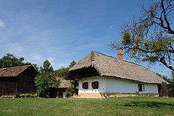
Szalafő (Slovene: Sola or Glava Zale) is a village in Vas county, Hungary. It lies near the borders with Austria and Slovenia and close to the source of the Zala River, which is located in the hills northwest of the village.
References
- ^ Szalafő at the Hungarian Central Statistical Office (Hungarian).
- Kozar-Mukič, Marija (1984). Slovensko Porabje. Ljubljana: Znanstveni inštitut Filozofske fakultete. p. 85.
- Marton, Jenő; Mózes, Krisztián; Wenszky, Nóra (2018). On two wheels without borders / Auf zwei Rädern ohne Grenzen. Budapest: Hibernia. p. 94.
- "Szalafő (Glava Zale)". Geopedia. Retrieved November 2, 2019.
46°52′N 16°22′E / 46.867°N 16.367°E / 46.867; 16.367
This Vas location article is a stub. You can help Misplaced Pages by expanding it. |