| This article needs additional citations for verification. Please help improve this article by adding citations to reliable sources. Unsourced material may be challenged and removed. Find sources: "Gumieńce" – news · newspapers · books · scholar · JSTOR (December 2009) (Learn how and when to remove this message) |
| Gumieńce | |
|---|---|
| Municipal neighbourhood | |
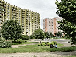
 Blocks of flats in Gumieńce Blocks of flats in Gumieńce | |
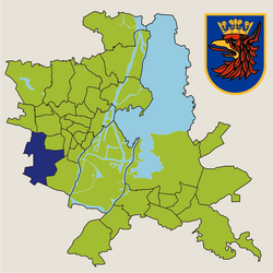
 Location of Gumieńce within Szczecin Location of Gumieńce within Szczecin | |
| Coordinates: 53°24′15″N 14°30′12″E / 53.40417°N 14.50333°E / 53.40417; 14.50333 | |
| Country | |
| Voivodeship | West Pomeranian |
| County/City | Szczecin |
| Population | |
| • Total | 19,120 |
| Time zone | UTC+1 (CET) |
| • Summer (DST) | UTC+2 (CEST) |
| Area code | +48 91 |
| Car plates | ZS |
Gumieńce is a municipal neighbourhood of the city of Szczecin, Poland situated on the left bank of Oder river, west of the Szczecin Old Town, Middle Town and Pomorzany. As of January 2011 it had a population of 19,120.
The Central Cemetery is located in eastern part of Gumieńce.
The area became part of the emerging Polish state under its first ruler Mieszko I around 967, and following Poland's fragmentation it formed part of the Duchy of Pomerania. During the Thirty Years' War, the settlement fell to the Swedish Empire. Later on, it passed to Prussia, and from 1871 to 1945 it was part of Germany, within which it was known as Scheune.
References
- "Zestawienie informacyjne o liczbie osób zameldowanych w Szczecinie" (in Polish). Urząd Miasta Szczecin. Archived from the original on 2007-12-30. Retrieved 2011-01-22.
- "Szczecin - Największe atrakcje". WP Turystyka (in Polish). Retrieved 25 December 2024.
- Labuda, Gerard (1993). "Chrystianizacja Pomorza (X–XIII stulecie)". Studia Gdańskie (in Polish). Vol. IX. Gdańsk-Oliwa. p. 47.
| Szczecin | ||||||||||
|---|---|---|---|---|---|---|---|---|---|---|
| Districts |
|  | ||||||||
| Historical districts | ||||||||||
This West Pomeranian Voivodeship location article is a stub. You can help Misplaced Pages by expanding it. |