| Szczurkowo | |
|---|---|
| Village | |
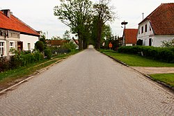
 View of the village View of the village | |
 | |
| Coordinates: 54°21′12″N 20°54′9″E / 54.35333°N 20.90250°E / 54.35333; 20.90250 | |
| Country | |
| Voivodeship | Warmian-Masurian |
| County | Bartoszyce |
| Gmina | Sępopol |
Szczurkowo (German: Schönbruch) is a village in the administrative district of Gmina Sępopol, within Bartoszyce County, Warmian-Masurian Voivodeship, in northern Poland, at the border of Kaliningrad Oblast of Russia. It lies approximately 12 kilometres (7 mi) north-west of Sępopol, 14 km (9 mi) north-east of Bartoszyce, and 69 km (43 mi) north-east of the regional capital Olsztyn.

Modern-day Szczurkowo is the southern part of the village that was partitioned in 1945 by the Poland–Russia border. The northern part is in the Kaliningrad Oblast and uninhabited.
Notable residents
- Otto von Bolschwing (1909–1982), SS-Hauptsturmführer, intelligence officer and businessman
Population
- 1931: 1,004
- 1939: 1,139
Wildlife
Szczurkowo is one of the largest nesting sites of the white stork in Poland, with several pairs breeding here annually.
References
- "Central Statistical Office (GUS) - TERYT (National Register of Territorial Land Apportionment Journal)" (in Polish). 2008-06-01.
- ^ Schütte, Peter. "Geschichte von Szczurkowo (PL) – Schirokoje (RUS) – Schönbruch" [History of Szczurkowo]. Informationszentrum Ostpreußen (in German). Retrieved 8 December 2024.
This Bartoszyce County location article is a stub. You can help Misplaced Pages by expanding it. |
