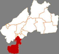
| Tailai County 泰来县T'ai-lai | |
|---|---|
| County | |
 Tailai in Qiqihar Tailai in Qiqihar | |
 Qiqihar in Heilongjiang Qiqihar in Heilongjiang | |
| Coordinates: 46°23′38″N 123°25′01″E / 46.394°N 123.417°E / 46.394; 123.417 | |
| Country | People's Republic of China |
| Province | Heilongjiang |
| Prefecture-level city | Qiqihar |
| Area | |
| • Total | 4,061 km (1,568 sq mi) |
| Population | |
| • Total | 302,027 |
| • Density | 74/km (190/sq mi) |
| Time zone | UTC+8 (China Standard) |
Tailai County (Chinese: 泰来县; pinyin: Tàilái Xiàn) is a county in the west of Heilongjiang province, People's Republic of China, bordering Inner Mongolia to the west and Jilin province to the south. It is the southernmost county-level division of the prefecture-level city of Qiqihar.

Administrative divisions
Tailai County is divided into 7 towns, 1 ethnic town and 2 ethnic townships.
- 7 towns
- Tailai (泰来镇), Pingyang (平洋镇), Tangchi (汤池镇), Tazicheng (塔子城镇), Daxing (大兴镇), Heping (和平镇), Keli (克利镇)
- 1 ethnic town
- Jiangqiao Mongol (江桥蒙古族镇)
- 2 ethnic townships
- Shengli Mongol (胜利蒙古族乡), Ningjiang Mongol (宁姜蒙古族乡)
Demographics
The population of the district was 322,562 in 1999.
Climate
| Climate data for Tailai (1991–2020 normals, extremes 1981–2010) | |||||||||||||
|---|---|---|---|---|---|---|---|---|---|---|---|---|---|
| Month | Jan | Feb | Mar | Apr | May | Jun | Jul | Aug | Sep | Oct | Nov | Dec | Year |
| Record high °C (°F) | 5.8 (42.4) |
11.4 (52.5) |
24.7 (76.5) |
33.2 (91.8) |
38.0 (100.4) |
39.9 (103.8) |
38.4 (101.1) |
36.4 (97.5) |
34.5 (94.1) |
28.4 (83.1) |
18.4 (65.1) |
6.9 (44.4) |
39.9 (103.8) |
| Mean daily maximum °C (°F) | −10.3 (13.5) |
−4.4 (24.1) |
4.3 (39.7) |
14.6 (58.3) |
22.3 (72.1) |
27.3 (81.1) |
28.9 (84.0) |
27.3 (81.1) |
22.0 (71.6) |
12.7 (54.9) |
0.3 (32.5) |
−8.9 (16.0) |
11.3 (52.4) |
| Daily mean °C (°F) | −16.7 (1.9) |
−11.3 (11.7) |
−2.4 (27.7) |
8.0 (46.4) |
16.0 (60.8) |
21.6 (70.9) |
24.0 (75.2) |
22.0 (71.6) |
15.7 (60.3) |
6.4 (43.5) |
−5.4 (22.3) |
−14.7 (5.5) |
5.3 (41.5) |
| Mean daily minimum °C (°F) | −21.9 (−7.4) |
−17.4 (0.7) |
−8.7 (16.3) |
1.3 (34.3) |
9.6 (49.3) |
16.1 (61.0) |
19.3 (66.7) |
17.2 (63.0) |
9.9 (49.8) |
0.9 (33.6) |
−10.2 (13.6) |
−19.5 (−3.1) |
−0.3 (31.5) |
| Record low °C (°F) | −36.9 (−34.4) |
−35.4 (−31.7) |
−26.9 (−16.4) |
−9.9 (14.2) |
−2.4 (27.7) |
2.8 (37.0) |
8.9 (48.0) |
7.0 (44.6) |
−1.3 (29.7) |
−15.5 (4.1) |
−25.9 (−14.6) |
−33.4 (−28.1) |
−36.9 (−34.4) |
| Average precipitation mm (inches) | 1.8 (0.07) |
2.2 (0.09) |
5.3 (0.21) |
17.9 (0.70) |
31.9 (1.26) |
84.4 (3.32) |
114.7 (4.52) |
86.7 (3.41) |
43.0 (1.69) |
13.1 (0.52) |
3.8 (0.15) |
4.2 (0.17) |
409 (16.11) |
| Average precipitation days (≥ 0.1 mm) | 2.9 | 1.9 | 3.0 | 4.3 | 7.7 | 11.6 | 12.4 | 10.3 | 7.4 | 4.1 | 3.2 | 4.7 | 73.5 |
| Average snowy days | 4.6 | 3.3 | 4.1 | 1.8 | 0 | 0 | 0 | 0 | 0 | 1.1 | 4.5 | 6.1 | 25.5 |
| Average relative humidity (%) | 63 | 54 | 45 | 41 | 46 | 61 | 72 | 72 | 63 | 54 | 57 | 64 | 58 |
| Mean monthly sunshine hours | 189.6 | 207.9 | 253.2 | 250.8 | 270.0 | 264.0 | 255.4 | 255.2 | 247.8 | 219.0 | 178.0 | 165.3 | 2,756.2 |
| Percent possible sunshine | 67 | 71 | 68 | 61 | 58 | 56 | 54 | 59 | 67 | 66 | 64 | 62 | 63 |
| Source: China Meteorological Administration | |||||||||||||
References
- "国家统计局 2019" (in Chinese). National Bureau of Statistics of the People's Republic of China. Retrieved 2021-12-07.
- (in English) National Population Statistics Materials by County and City - 1999 Period, in China County & City Population 1999, Harvard China Historical GIS
- 中国气象数据网 – WeatherBk Data (in Simplified Chinese). China Meteorological Administration. Retrieved 5 July 2023.
- 中国气象数据网 (in Simplified Chinese). China Meteorological Administration. Retrieved 5 July 2023.
External links
- (in Chinese) Government site - Google translation
| County-level divisions of Heilongjiang Province | |||||||||||||||||||||||
|---|---|---|---|---|---|---|---|---|---|---|---|---|---|---|---|---|---|---|---|---|---|---|---|
| Harbin (capital) | |||||||||||||||||||||||
| Sub-provincial city |
| ||||||||||||||||||||||
| Prefecture-level cities |
| ||||||||||||||||||||||
| Prefecture |
| ||||||||||||||||||||||
| These are administrative zones, which are not standard units of local government, though they do function as such.
Formally part of Oroqen Banner in Inner Mongolia but administered de facto by Daxing'anling Prefecture in Heilongjiang. Formally part of Huma County. | |||||||||||||||||||||||
This Heilongjiang location article is a stub. You can help Misplaced Pages by expanding it. |