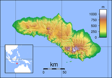
| Lede Kalumbang Airport Bandar Udara Lede Kalumbang | |||||||||||
|---|---|---|---|---|---|---|---|---|---|---|---|
 | |||||||||||
| Summary | |||||||||||
| Airport type | Public | ||||||||||
| Owner | Government of Indonesia | ||||||||||
| Operator | Ministry of Transportation | ||||||||||
| Serves | Tambolaka | ||||||||||
| Location | Southwest Sumba Regency, East Nusa Tenggara, Indonesia | ||||||||||
| Time zone | WITA (UTC+08:00) | ||||||||||
| Elevation AMSL | 47.85 m / 157 ft | ||||||||||
| Coordinates | 09°24′34.98″S 119°14′40.18″E / 9.4097167°S 119.2444944°E / -9.4097167; 119.2444944 | ||||||||||
| Map | |||||||||||
 | |||||||||||
| Runways | |||||||||||
| |||||||||||
Lede Kalumbang Airport (Indonesian: Bandar Udara Lede Kalumbang) (IATA: TMC, ICAO: WATK), formerly Tambolaka Airport, is an airport in Tambolaka, Southwest Sumba Regency, East Nusa Tenggara, Indonesia. A new terminal inaugurated in 2015 expanded passenger services. A cafe and shops are available at the terminal, and there is a car park and some taxi stands outside the terminal.
Terminals, airlines and destinations
| Airlines | Destinations |
|---|---|
| Nam Air | Denpasar, Kupang |
| Wings Air | Denpasar, Kupang |
Accidents and incidents
- On February 11, 2006, Adam Air Flight 782, registration number PK-KKE, lost navigational and communications systems twenty minutes into a flight from Jakarta to Makassar, South Sulawesi. The plane was subsequently flown into a radar "black spot" and was lost for several hours, eventually making an emergency landing at Tambolaka Airport, Sumba (on a different island 481 km away from their intended destination, and southeast from their origin, instead of north-east). The pilot was fired because the Adam Air flight violated multiple safety regulations, including removing an aircraft before it was due for inspection by aviation authorities.
References
- "Direktorat Jenderal Perhubungan Udara".
- B737 makes emergency landing after nav and comm systems failure - Aviation Safety Network - retrieved March 4, 2007.
External links
| Airports in Indonesia (Statistics) | |||||||||||||||||||||||
|---|---|---|---|---|---|---|---|---|---|---|---|---|---|---|---|---|---|---|---|---|---|---|---|
| |||||||||||||||||||||||
| |||||||||||||||||||||||
| |||||||||||||||||||||||
| |||||||||||||||||||||||
| |||||||||||||||||||||||
| |||||||||||||||||||||||
| |||||||||||||||||||||||
| Names in bold are international airports; names of international airports marked with ‡ have Visa on Arrival (VoA) facility Names of airports marked with ⬠ are exclusively or also served as military airbase | |||||||||||||||||||||||
This article about an Indonesian airport is a stub. You can help Misplaced Pages by expanding it. |
This Gorontalo location article is a stub. You can help Misplaced Pages by expanding it. |