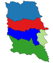
Taungoo District (also Taungngu, Toungoo, Burmese: တောင်ငူခရိုင်) is a district of the Bago Division in central Burma (Myanmar). The capital lies at Taungoo. This district covers an area of around 10,627 square kilometers (4,103 square miles).

History
Taungoo District was created by the Pagan Dynasty in the 1280s, and was much larger. It was ruled by appointed governors through succeeding dynasties. In 1510, Taungoo District briefly became the small, independent kingdom of Taunggyi. But within twenty years that kingdom soon controlled most of Burma, the capital was moved to Pegu, and Taungoo became a district again. By the mid-19th century, Taungoo was governed by a local governor appointed by the Konbaung kings. The Taungoo District consisted of 52 wards, including today's Pyinmana and Naypyidaw regions. The Taungoo District was cut in half after the Second Anglo-Burmese War. The British annexed the southern half, including the city of Taungoo while the northern portion, including Pyinmana and Ela, remained Burmese.
Townships

The district contains the following townships
References
- "Burma: Second-Order Administrative Divisions (Districts)" The Permanent Committee of Geographic Names (PCGN), United Kingdom, from Internet Archive
- Measured at https://www.google.com/maps/place/Taungoo,+Myanmar+(Burma)/@19.02542,95.0170281,8.76z/data=!4m6!3m5!1s0x30c42c19856f0715:0x4135b9564f2e599f!8m2!3d18.8932985!4d96.2375947!16s%2Fm%2F0cp1vdv!5m1!1e4?authuser=0&entry=ttu&g_ep=EgoyMDI0MTEwNi4wIKXMDSoASAFQAw%3D%3D google.com/maps on 10 November 2024.
- Shwe Yinnma Oo (2010-08-02). "Taungoo prepares for 500th birthday". The Myanmar Times. Archived from the original on 2010-08-04.
- Sir James George Scott, John Percy Hardiman (1901). Gazetteer of Upper Burma and the Shan States, Part 2. Vol. 3. Printed by the superintendent, Government printing, Burma. p. 374.
| Bago Region | ||||||||
|---|---|---|---|---|---|---|---|---|
| Capital: Bago | ||||||||
| East Bago Region |
|   | ||||||
| West Bago Region |
| |||||||
| Main cities and towns | ||||||||
18°38′N 96°25′E / 18.633°N 96.417°E / 18.633; 96.417
This Bago Region location article is a stub. You can help Misplaced Pages by expanding it. |