Place in Chatham Islands, New Zealand
| Te One | |
|---|---|
  | |
| Coordinates: 43°55′58″S 176°31′40″W / 43.932831°S 176.527718°W / -43.932831; -176.527718 | |
| Country | |
| Territorial authority | Chatham Islands |
| Population | |
| • Total | 58 |
| Time zone | Chatham Standard Time Zone |
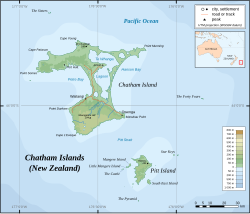
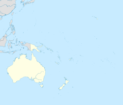
Te One is a settlement on the Chatham Islands. It is located in Petre Bay, on the west coast of the main island, just north of the port settlement of Waitangi.
Marae
Whakamaharatanga, a marae (meeting ground) of Ngāti Mutunga, is located in Te One. It includes the Whakamaharatanga wharenui (meeting house).
In October 2020, the New Zealand Government committed $198,318 from the Provincial Growth Fund to upgrade the marae, creating 6 jobs.
Education
Te One School is a co-educational state primary school, with a roll of 62 as of November 2024.
It is one of the most isolated schools in New Zealand, which makes it harder for the school to attract teachers and access resources.
References
- "Te Kāhui Māngai directory". tkm.govt.nz. Te Puni Kōkiri.
- "Māori Maps". maorimaps.com. Te Potiki National Trust.
- "Marae Announcements" (Excel). growregions.govt.nz. Provincial Growth Fund. 9 October 2020.
- "Ministry of Education School Profile". educationcounts.govt.nz. Ministry of Education.
- "Education Review Office Report". ero.govt.nz. Education Review Office.
- Jackson, Amy (28 January 2018). "City schools v rural schools: Wellington's Kea Reid and Taranaki's Zack Radford compare typical school days". stuff.co.nz.
| Chatham Islands | ||
|---|---|---|
| Islands (by English name) |  | |
| Islands (by Māori/Moriori name) | ||
| Coastal landforms | ||
| Populated places | ||
| Other geographic features | ||
| Historical events | ||
This article about the geography of New Zealand's outlying islands is a stub. You can help Misplaced Pages by expanding it. |