Census-designated place in Louisiana, United States
| Terrytown, Louisiana | |
|---|---|
| Census-designated place | |
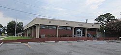
 Terrytown Library Terrytown Library | |
 | |
| Coordinates: 29°54′08″N 90°01′46″W / 29.90222°N 90.02944°W / 29.90222; -90.02944 | |
| Country | United States |
| State | Louisiana |
| Parish | Jefferson |
| Area | |
| • Total | 3.70 sq mi (9.57 km) |
| • Land | 3.66 sq mi (9.49 km) |
| • Water | 0.03 sq mi (0.08 km) |
| Elevation | −3 ft (−0.9 m) |
| Population | |
| • Total | 25,278 |
| • Density | 6,899.02/sq mi (2,663.80/km) |
| Time zone | UTC-6 (CST) |
| • Summer (DST) | UTC-5 (CDT) |
| ZIP Code | 70056 |
| Area code | 504 |
| GNIS feature ID | 2402921 |
Terrytown is an unincorporated community and census-designated place (CDP) in Jefferson Parish, Louisiana, United States. It is on the "Westbank" (to the south) of the Mississippi River. It is a suburb within the New Orleans–Metairie–Kenner metropolitan statistical area. The population was 23,319 at the 2010 census, and 25,278 in 2020.
Terrytown was opened to a media tour on March 5, 1960, showcasing the newest of concepts in home construction at the time, with the original homes having all plumbing in one wall. The community was opened to the public and considered founded on March 6, 1960, by subdivision developer Paul Kapelow, who named the town after his first daughter, Terry Kapelow. Terrytown includes Oakwood Center, a major shopping mall in the New Orleans metropolitan area.
Geography
Terrytown is located on the eastern edge of Jefferson Parish at 29°54′8″N 90°1′46″W / 29.90222°N 90.02944°W / 29.90222; -90.02944 (29.902356, -90.029475). It is bordered to the northeast by New Orleans in Orleans Parish, to the west by Gretna, to the south by Timberlane, and to the southeast by Belle Chasse in Plaquemines Parish. According to the United States Census Bureau, the Terrytown CDP has a total area of 3.72 square miles (9.64 km), of which 3.68 square miles (9.52 km) are land and 0.05 square miles (0.12 km), or 1.24%, are water.
Louisiana Highway 23 (Belle Chasse Highway) forms the southwest border of Terrytown, and Highway 428 (Behrman Highway) runs through the eastern part of the community. The two main intersecting streets in Terrytown are Terry Parkway, running north and south, and Carol Sue Avenue (named for Paul Kapelow's second daughter, Carol Sue Kapelow), running east and west.
Demographics
| Census | Pop. | Note | %± |
|---|---|---|---|
| 1970 | 13,832 | — | |
| 1980 | 23,548 | 70.2% | |
| 1990 | 23,787 | 1.0% | |
| 2000 | 25,430 | 6.9% | |
| 2010 | 23,319 | −8.3% | |
| 2020 | 25,278 | 8.4% | |
| source: | |||
| Race / Ethnicity (NH = Non-Hispanic) | Pop 2000 | Pop 2010 | Pop 2020 | % 2000 | % 2010 | % 2020 |
|---|---|---|---|---|---|---|
| White alone (NH) | 12,921 | 8,708 | 6,518 | 50.81% | 37.34% | 25.79% |
| Black or African American alone (NH) | 8,730 | 9,093 | 9,660 | 34.33% | 38.99% | 38.22% |
| Native American or Alaska Native alone (NH) | 111 | 77 | 45 | 0.44% | 0.33% | 0.18% |
| Asian alone (NH) | 880 | 941 | 1,184 | 3.46% | 4.04% | 4.68% |
| Pacific Islander alone (NH) | 10 | 11 | 21 | 0.04% | 0.05% | 0.08% |
| Other race alone (NH) | 66 | 75 | 130 | 0.26% | 0.32% | 0.51% |
| Mixed race or Multiracial (NH) | 506 | 346 | 708 | 1.99% | 1.48% | 2.80% |
| Hispanic or Latino (any race) | 2,206 | 4,068 | 7,012 | 8.67% | 17.45% | 27.74% |
| Total | 25,430 | 23,319 | 25,278 | 100.00% | 100.00% | 100.00% |
According to the 2010 U.S. census, there were 23,320 people, 8,121 households, and 6,458 families residing in the CDP. The population density was 6,347 inhabitants per square mile (2,451/km). There were 9,401 housing units at an average density of 2,412 per square mile (931/km). The racial makeup of the CDP was 34.90% White, 32.80% African American, 0.61% Native American, 10.34% Asian, 0.28% Pacific Islander, 5.82% from other races, and 2.98% from two or more races. Hispanic or Latino American people of any race were 28.97% of the population.
There were 9,344 households, out of which 38.2% had children under the age of 18 living with them, 47.2% were married couples living together, 20.0% had a female householder with no husband present, and 27.3% were non-families. 22.2% of all households were made up of individuals, and 5.0% had someone living alone who was 65 years of age or older. The average household size was 2.72 and the average family size was 3.19.
In the CDP, the population was spread out, with 29.0% under the age of 18, 10.1% from 18 to 24, 32.2% from 25 to 44, 20.7% from 45 to 64, and 7.9% who were 65 years of age or older. The median age was 32 years. For every 100 females, there were 90.7 males. For every 100 females age 18 and over, there were 85.9 males.
The median income for a household in the CDP was $36,897, and the median income for a family was $41,963. Males had a median income of $31,421 versus $23,241 for females. The per capita income for the CDP was $16,725. About 13.6% of families and 15.5% of the population were below the poverty line, including 24.3% of those under age 18 and 6.5% of those age 65 or over.
The 2019 American Community Survey estimated 24,953 people lived in the CDP. The racial and ethnic makeup was 32.1% non-Hispanic white, 39.4% Black or African American, 1.2% Native American, 3.1% Asian, 11.7% some other race, 4.7% two or more races, and 23.8% Hispanic and Latino American of any race. The median household income was $46,638, and 22.9% of the population lived at or below the poverty line. A year later, the 2020 U.S. census determined there were 25,278 people, 8,609 households, and 5,771 families residing in the CDP. Among the racial and ethnic demographic, 38.22% were Black or African American, 25.79% non-Hispanic white, 0.18% Native American, 4.68% Asian, 0.08% Pacific Islander, 3.32% two or more races, and 27.74% Hispanic or Latino American of any race.
Religiously, and in common with most of southern Louisiana, the predominant faith affiliated with has been Christianity and its Catholic Church, followed by Baptists of varying denominations. Among the Catholic population, most are served by the Roman Catholic Archdiocese of New Orleans; Baptists are divided among the Southern Baptist Convention and historically Black or African American Baptist denominations such as the National Baptist Convention, USA and National Baptist Convention of America among others.
Education


Jefferson Parish Public Schools operates public schools which take students from the CDP.
Zoned schools include the following: For elementary school, Geraldine Boudreaux and Terrytown Elementary Schools in Terrytown serve most of Terrytown, while William Hart Elementary, in Gretna, serves a small portion. A small portion is zoned to McDonogh 26 in Gretna. Almost all of Terrytown is zoned to Livudais Middle School in Terrytown, while a small portion is zoned to Marrero Middle School. All residents are zoned to West Jefferson High School in Harvey.
In regards to advanced studies academies, residents are zoned to the Gretna Academy.
Kate Middleton Elementary in Gretna previously served a portion of Terrytown; it closed in 2012.
Private schools include:
- Christ the King Catholic Elementary School (Closed 2020)
- Stepping Stones Montessori
- Terrytown Academy
- Elmwood Park Academy
Jefferson Parish Library operates the Terrytown Library. The library is across the street from the Terrytown Playground, shares a parking lot with the Terrytown Golden Age Center, and is near Terrytown Elementary. The library first opened on October 9, 1974. In December 2009 the library closed for renovations. Chris Roberts, a parish council member, provided riverboat gaming funds to help renovate the library. The renovated library reopened on September 8, 2010 with a new main entrance.
Notable people
- Bryan Adams, former member of the Louisiana House of Representatives from District 85 in Jefferson Parish, 2012–2016
References
- "2020 U.S. Gazetteer Files". United States Census Bureau. Retrieved March 20, 2022.
- ^ U.S. Geological Survey Geographic Names Information System: Terrytown, Louisiana
- ^ "Geographic Identifiers: 2010 Census Summary File 1 (G001): Terrytown CDP, Louisiana". American Factfinder. U.S. Census Bureau. Archived from the original on February 13, 2020. Retrieved July 20, 2018.
- "QuickFacts: Terrytown CDP, Louisiana". U.S. Census Bureau. Retrieved August 12, 2021.
- "CENSUS OF POPULATION AND HOUSING (1790-2000)". U.S. Census Bureau. Retrieved July 17, 2010.
- "P004 Hispanic or Latino, and Not Hispanic or Latino by Race – 2000: DEC Summary File 1 – Terrytown CDP, Louisiana". United States Census Bureau.
- "P2 Hispanic or Latino, and Not Hispanic or Latino by Race – 2010: DEC Redistricting Data (PL 94-171) – Terrytown CDP, Louisiana". United States Census Bureau.
- "P2 Hispanic or Latino, and Not Hispanic or Latino by Race – 2020: DEC Redistricting Data (PL 94-171) – Terrytown CDP, Louisiana". United States Census Bureau.
- "Terrytown CDP QuickFacts from the US Census Bureau". Archived from the original on November 3, 2013. Retrieved November 2, 2013.
- "U.S. Census website". United States Census Bureau. Retrieved January 31, 2008.
- "Geography Profile: Terrytown CDP, Louisiana". data.census.gov. Retrieved August 12, 2021.
- "2020 Race and Population Totals". data.census.gov. Retrieved December 28, 2021.
- "Parishes". Archdiocese of New Orleans. Retrieved January 5, 2022.
- "SBC Churches Directory". Southern Baptist Convention. Retrieved January 5, 2022.
- "2020 CENSUS - SCHOOL DISTRICT REFERENCE MAP: Jefferson Parish, LA" (PDF). U.S. Census Bureau. Retrieved March 2, 2024. - Text list
- "2020 CENSUS - CENSUS BLOCK MAP: Terrytown CDP, LA" (PDF). U.S. Census Bureau. Retrieved March 3, 2024.
"2010 CENSUS - CENSUS BLOCK MAP (INDEX): Terrytown CDP, LA" (Archive). U.S. Census Bureau. Retrieved on May 18, 2014. - "Elementary School Districts 2023-24 West Bank of Jefferson Parish Louisiana" (PDF). Jefferson Parish Public Schools. Retrieved March 2, 2024.
- "Middle School Districts 2023-24 West Bank of Jefferson Parish Louisiana" (PDF). Jefferson Parish Public Schools. Retrieved March 2, 2024.
- "High School Districts 2012-2013 West Bank of Jefferson Parish Louisiana Archived 2013-09-05 at the Wayback Machine" (Archive). Jefferson Parish Public Schools. Retrieved on May 18, 2014.
- "Westbank Advanced Studies Academies Attendance Zones Archived 2013-09-05 at the Wayback Machine" (Archive). Jefferson Parish Public Schools. Retrieved on May 18, 2014.
- "Elementary School Districts 2009-2010 West Bank of Jefferson Parish Louisiana." (Archive) Jefferson Parish Public School System. Retrieved on September 26, 2010.
- Waller, Mark. "Group of schools shuts down as Jefferson Parish adjourns for the summer." The Times-Picayune. May 25, 2012. Retrieved on April 4, 2013.
- "Christ the King School in Terrytown to close at end of the school year | Education | nola.com".
- "Terrytown CDP, Louisiana." U.S. Census Bureau. Retrieved on September 28, 2010.
- ^ "Terrytown Library." Jefferson Parish Library. Retrieved on September 28, 2010.
External links
- City-Data page on Terrytown
- Key to the City page on Terrytown
- IDcide page on Terrytown
- Terrytown Library
- Manav Tanneeru and Jennifer Pangyanszki, "Rebuilding homes, rebuilding lives: Terrytown residents appraise the damage done" . CNN.com, Sept. 7, 2005.
Schools:
- Livaudais Middle School
- Elementary schools: Geraldine Boudreaux and Terrytown
| Municipalities and communities of Jefferson Parish, Louisiana, United States | ||
|---|---|---|
| Parish seat: Gretna | ||
| Cities |  | |
| Towns | ||
| CDPs | ||
| Other unincorporated communities | ||