| This article needs additional citations for verification. Please help improve this article by adding citations to reliable sources. Unsourced material may be challenged and removed. Find sources: "Thorncombe Beacon" – news · newspapers · books · scholar · JSTOR (September 2022) (Learn how and when to remove this message) |
| Thorncombe Beacon | |
|---|---|
| Highest point | |
| Elevation | 157 metres (515 ft) |
| Coordinates | 50°43′12″N 2°48′05″W / 50.7200°N 2.8013°W / 50.7200; -2.8013 |
| Geography | |
 | |
| Country | United Kingdom |
| State | Dorset |
| Settlement | Symondsbury |
| OS grid | SY437913 |
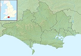
Thorncombe Beacon is a hill between Bridport and Charmouth in Dorset, England. It lies about 1 kilometre (0.62 mi) west of Eype Mouth and 2 kilometres (1.2 mi) east of Seatown. It is in the south-west part of Symondsbury parish close to the parish of Chideock. It is 157 metres (515 ft) high, compared to 191 metres (627 ft) for Golden Cap which lies about 3 kilometres (1.9 mi) to the west. It forms part of the Jurassic Coast, a World Heritage Site and the South West Coast Path and the Monarch's Way skirt the hilltop.
The hill is owned by the National Trust. Three bowl barrows to the north-east of the summit constitute a scheduled monument.
References
- Historic England. "Three bowl barrows north east of Thorncombe Beacon, 160m, 190m and 400m south west of Down House (1016101)". National Heritage List for England. Retrieved 19 September 2022.
![]() Media related to Thorncombe Beacon at Wikimedia Commons
Media related to Thorncombe Beacon at Wikimedia Commons