| Tinjan Antignana | |
|---|---|
| Municipality | |
 | |
 Flag Flag | |
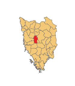
 Location of Tinjan in Istria Location of Tinjan in Istria | |
 | |
| Coordinates: 45°13′02″N 13°50′20″E / 45.21722°N 13.83889°E / 45.21722; 13.83889 | |
| Country | |
| County | |
| Area | |
| • Municipality | 20.4 sq mi (52.8 km) |
| • Urban | 4.2 sq mi (10.8 km) |
| Population | |
| • Municipality | 1,729 |
| • Density | 85/sq mi (33/km) |
| • Urban | 433 |
| • Urban density | 100/sq mi (40/km) |
| Time zone | UTC+1 (CET) |
| • Summer (DST) | UTC+2 (CEST) |
| Postal code | 52465 Tar |
| Area code | 052 |
| Website | tinjan |
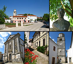
Tinjan (Italian: Antignana) is a village and municipality in Istria, Croatia.
Tinjan is located is 50 km north of Pula and 10 km southwest of Pazin, in the Draga valley. The Coat of Arms of Tinjan is azure on a base vert a tower argent behind walls of the same. This is based on the historical pattern.
Demographics
According to the 2021 census, its population was 1,729 with 433 living in the village proper. The total population was 1,684 in 2011, distributed in the following settlements:
- Brčići/Bercici, population 100
- Brečevići/Brecovici, population 187
- Jakovici/Iacovici, population 268
- Kringa/Corridico, population 315
- Muntrilj/Montreo, population 77
- Radetići/Radetici, population 210
- Tinjan/Antignana, population 417
- Žužići/Zusi, population 110
References
- Register of spatial units of the State Geodetic Administration of the Republic of Croatia. Wikidata Q119585703.
- ^ "Population by Age and Sex, by Settlements" (xlsx). Census of Population, Households and Dwellings in 2021. Zagreb: Croatian Bureau of Statistics. 2022.
- "Population by Age and Sex, by Settlements, 2011 Census: Tinjan". Census of Population, Households and Dwellings 2011. Zagreb: Croatian Bureau of Statistics. December 2012.
External links
| Settlements of Tinjan | |
|---|---|
| Subdivisions of Istria County | ||
|---|---|---|
| Cities and towns |  | |
| Municipalities | ||
This Istria County geography article is a stub. You can help Misplaced Pages by expanding it. |