| This article relies largely or entirely on a single source. Relevant discussion may be found on the talk page. Please help improve this article by introducing citations to additional sources. Find sources: "Tokomaru River" – news · newspapers · books · scholar · JSTOR (May 2024) |
River in New Zealand
| Tokomaru River | |
|---|---|
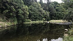
 Tokomaru River at Horseshoe Bend Reserve Tokomaru River at Horseshoe Bend Reserve | |
| Location | |
| Country | |
| Physical characteristics | |
| Source | |
| • location | Tararua Range |
| Mouth | |
| • location | Manawatū River |
| Length | 27 km (17 mi) |
The Tokomaru River is a river of the Manawatū-Whanganui Region of the North Island of New Zealand. It rises to the southeast of Shannon and initially flows northeast down a long valley in the Tararua Range before turning northwest to reach the edge of the Manawatū Plain near the town of Tokomaru. From there it turns southwest, reaching the Manawatū River 3 km (1.9 mi) north of Shannon.
See also
References
- "Place name detail: Tokomaru River". New Zealand Gazetteer. New Zealand Geographic Board. Retrieved 12 July 2009.
40°32′S 175°24′E / 40.533°S 175.400°E / -40.533; 175.400
This article about a river in Manawatū-Whanganui is a stub. You can help Misplaced Pages by expanding it. |