| Trị An Reservoir | |
|---|---|
| Trị An Lake | |
| Hồ Trị An (Vietnamese) | |
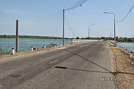
 A bridge across the reservoir in Vĩnh Cửu district A bridge across the reservoir in Vĩnh Cửu district | |
 | |
| Location | Đồng Nai province |
| Coordinates | 11°11′09″N 107°09′04″E / 11.18583°N 107.15111°E / 11.18583; 107.15111 |
| Type | Reservoir |
| River sources | Đồng Nai River, La Ngà River |
| Basin countries | Vietnam |
| Built | 1984 (1984) |
| First flooded | 1987 (1987) |
| Surface area | 323 square kilometres (125 sq mi) |
| Water volume | ~ 2.8 billion cubic metres (99×10 |
Trị An Reservoir, also known as Trị An Lake (Vietnamese: Hồ Trị An), is an artificial lake located on the Dong Nai River, with the territory of Vĩnh Cửu, Định Quán, Thống Nhất and Trảng Bom districts, all in Đồng Nai province. It stores, then supplies water for Trị An Dam.
It has an area of 323 square kilometres (80,000 acres) and a capacity of 2.7 billion cubic metres (9.5×10 cu ft). In the north of the lake is Cát Tiên National Park. There are 76 small islands in the lake, some of which are inhabited. Today, it is also a picnic spot in Đồng Nai province.
References
- "Dong Nai proposes 8 solar power projects on Tri An lake". VietnamPlus.
- "Thủy điện Trị An: Dấu ấn hữu nghị Việt - Nga (English: Tri An Dam: A mark of Vietnam - Russia friendship)". Vietnam Electricity Corporation.
- "Hệ thống đảo trên hồ Trị An: Tiềm năng chưa khai thác hết (English: The island system on Trị An lake: Untapped potential)". Đồng Nai newspaper.
- "Phát triển du lịch vùng lòng hồ Trị An (English: Developing tourism in Tri An lake)". Sài Gòn Giải Phóng newspaper.
External links
 Media related to Tri An Reservoir at Wikimedia Commons
| Đồng Nai province | ||
|---|---|---|
| Capital: Biên Hòa | ||
| Biên Hòa |  | |
| Long Khánh |
| |
| Cẩm Mỹ District |
| |
| Định Quán District |
| |
| Long Thành District |
| |
| Nhơn Trạch District |
| |
| Tân Phú District | ||
| Thống Nhất District |
| |
| Trảng Bom District |
| |
| Vĩnh Cửu District | ||
| Xuân Lộc District | ||
| Popular Place | ||