| Tromøy Bridge Tromøybrua / Tromøybroa | |
|---|---|
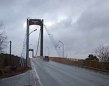
 View of the bridge seen from the mainland View of the bridge seen from the mainland | |
| Coordinates | 58°28′16″N 08°49′23″E / 58.47111°N 8.82306°E / 58.47111; 8.82306 |
| Carries | |
| Crosses | Tromøysundet |
| Locale | Arendal, Norway |
| Characteristics | |
| Design | Suspension bridge |
| Material | Concrete and steel |
| Total length | 400 metres (1,300 ft) |
| Longest span | 240 metres (790 ft) |
| No. of spans | 12 |
| Clearance above | 37 metres (121 ft) |
| History | |
| Opened | 21 Oct 1961 |
| Statistics | |
| Daily traffic | 8,350 (in 2008) |
| Location | |
The Tromøy Bridge (Norwegian: Tromøybrua) is a suspension bridge that crosses the Tromøysundet strait in the municipality of Arendal in Agder county, Norway. It connects the island of Tromøya with the mainland, about 3.5 kilometres (2.2 mi) northeast of the town of Arendal.
The bridge is part of Norwegian County Road 409 and it opened on 21 October 1961 by Trygve Bratteli, the Minister of Transport and Communications. The bridge originally cost 7 million kr. The 400-metre (1,300 ft) long bridge has 12 spans, the longest of which is 240 metres (790 ft). The bridge has a 37 metres (121 ft) high clearance underneath it so ships may pass under it. In 2008, the annual average daily traffic was 8,350 cars per day.

Its building was prepared by a special committee which was chaired by Christian Stray during its entire existence from 1938 to 1961.
See also
References
- Merzagora, Eugenio A. (ed.). "Road Viaducts & Bridges in Norway (499-200 m)". Norske bruer og viadukter. Retrieved 2017-11-25.
- "Tromoy Bridge". BridgeInfo.net. Retrieved 2017-11-25.
- ^ "Da Tromøya ble landfast" (in Norwegian). Avtrykk fra Aust-Agder. Retrieved 2017-11-25.
- Gauslaa, Einar (1966). "Stray, Christian". In Jansen, Jonas; Anker, Øyvind; Bøe, Gunvald (eds.). Norsk biografisk leksikon (in Norwegian). Vol. 15 (1st ed.). Oslo: Aschehoug. pp. 115–117.
This article about a bridge in Norway is a stub. You can help Misplaced Pages by expanding it. |