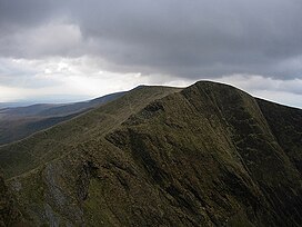
| Trum y Ddysgl | |
|---|---|
 Trum y Ddysgl from Mynydd Drws-y-coed Trum y Ddysgl from Mynydd Drws-y-coed | |
| Highest point | |
| Elevation | 709 m (2,326 ft) |
| Prominence | 204 m (669 ft) |
| Listing | Marilyn, Hewitt, Nuttall |
| Naming | |
| Language of name | Welsh |
| Geography | |
| Location | Gwynedd, Wales |
| Parent range | Moel Hebog |
| Topo map | OS Landranger 115, OS Outdoor Leisure 17 |
| Climbing | |
| Easiest route | Walk |
| Name | Grid ref | Height | Status |
|---|---|---|---|
| Mynydd Drws-y-Coed | 695 m (2,280 ft) | Hewitt, Nuttall | |
| Mynydd Tal-y-Mignedd | 653 m (2,142 ft) | Hewitt, Nuttall |
Trum y Ddysgl is a mountain in Snowdonia, north Wales and is the second highest summit on the Nantlle Ridge. It is also one half of the two Marilyns that make up the ridge, the other being Craig Cwm Silyn.
The mountain has a dramatic morphology, with two aretes, dark glacial cwms and rocky character. There are views of Snowdonia, with Mynydd Mawr, Snowdon (Yr Wyddfa) and Moel Hebog being close neighbours. The peak also has three other tops, which all in all form a rocky and relatively narrow part of the Nantlle ridge.
References
- Nuttall, John & Anne (1999). The Mountains of England & Wales - Volume 1: Wales (2nd edition ed.). Milnthorpe, Cumbria: Cicerone. ISBN 1-85284-304-7.
53°02′32″N 4°10′19″W / 53.0421608°N 4.1720484°W / 53.0421608; -4.1720484
This Gwynedd location article is a stub. You can help Misplaced Pages by expanding it. |