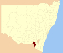
| Tumbarumba Shire New South Wales | |||||||||||||||
|---|---|---|---|---|---|---|---|---|---|---|---|---|---|---|---|
 Location in New South Wales Location in New South Wales | |||||||||||||||
| Coordinates | 35°45′S 148°00′E / 35.750°S 148.000°E / -35.750; 148.000 | ||||||||||||||
| Population | 3,521 (2013 est) | ||||||||||||||
| • Density | 0.80150/km (2.0759/sq mi) | ||||||||||||||
| Abolished | 12 May 2016 (2016-05-12) | ||||||||||||||
| Area | 4,393 km (1,696.1 sq mi) | ||||||||||||||
| Mayor | Cr. Ian Chaffey (Independent) | ||||||||||||||
| Council seat | Tumbarumba | ||||||||||||||
| Region | Riverina | ||||||||||||||
| State electorate(s) | Albury | ||||||||||||||
| Federal division(s) | Division of Riverina | ||||||||||||||
| Website | Tumbarumba Shire | ||||||||||||||
| |||||||||||||||
Tumbarumba Shire was a local government area in the eastern Riverina region, located in the foothills of the Snowy Mountains, on the upper reaches of the Murray River in New South Wales, Australia. It came into existence in 1906. Prior to this the area covered by the shire was unincorporated. It included the town of Tumbarumba and the small towns of Rosewood, Tooma, Khancoban and Jingellic.
A 2015 review of local government boundaries recommended that the Tumbarumba Shire merge with the Tumut Shire to form a new council. This recommendation was not supported by any of the preceding IPART and Tcorp assessments, which recommended a merger between Tumut and Gundagai shires instead. When the NSW Government released their proposal in December 2015, the Government's website stated that the proposal was 'broadly consistent with Tumut Council's stated preference'. Tumut Council submitted its preferences during a consultation period following the IPART's 'Fit for the Future' report, in October 2015 after it was found 'Not Fit'. Tumbarumba Shire Council did not elect any merger partners as part of this process, with the finding it was 'Fit' as a 'Rural Council'.
As a result, many residents of Tumbarumba Shire viewed Tumut Shire Council's choice to nominate a merger of the Gundagai, Tumbarumba, and Tumut shires as the catalyst behind the NSW Government proposal to merge the Tumbarumba Shire with Tumut Shire, (which was never one of Tumut Shire Council's stated preference). The resulting opposition by the residents of Tumbarumba Shire was almost unanimous, with a publicly convened 'Save Tumbarumba Shire' committee executing an active grass roots, public campaign.
The NSW Government proposal would see a combined Shire with an area of 8,960 square kilometres (3,460 sq mi) and support a population of approximately 14,953. On 12 May 2016, the NSW Government dissolved Tumbarumba Shire and along with Tumut Shire and merged the councils to form the Snowy Valleys Council.
The last mayor of Tumbarumba Shire was Cr. Ian Chaffey, an independent politician.
Council
Current composition and election method
At the time of dissolution, Tumbarumba Shire Council was composed of eight councillors elected proportionally as a single ward. All councillors were elected for a fixed four-year term of office. The mayor was elected by the councillors at the first meeting of the council. The last election was held on 8 September 2012 and the makeup of the council was as follows:
| Party | Councillors | |
|---|---|---|
| Independents and Unaligned | 8 | |
| Total | 8 | |
The final Council, elected in 2012, in order of election, was:
| Councillor | Party | Notes | |
|---|---|---|---|
| Julie Giddings | Unaligned | ||
| Ian Chaffey | Independent | Mayor | |
| Rodney Shaw | Unaligned | ||
| Tony a'Beckett | Unaligned | ||
| Alan Becke | Independent | ||
| Brent Livermore | Independent | Deputy Mayor from Sept 2014 | |
| Sue Fletcher | Unaligned | ||
| George Martin | Unaligned | ||
References
- "3218.0 Regional Population Growth, Australia. Table 1. Estimated Resident Population, Local Government Areas, New South Wales". 3 April 2014. Retrieved 11 September 2014.
- "Tumbarumba Shire Council". Department of Local Government. Retrieved 8 November 2006.
- ^ "Council and Councillors". Council. Tumbarumba Shire Council. September 2012. Retrieved 30 September 2012.
- "Merger proposal: Tumbarumba Shire Council, Tumut Shire Council" (PDF). Government of New South Wales. January 2016. p. 7. Retrieved 10 March 2016.
- "Snowy Valley Council". Stronger Councils. Government of New South Wales. 12 May 2016. Retrieved 13 May 2016.
- ^ "Tumbarumba Shire Council: Summary of First Preference and Group Votes for each Candidate". Local Government Elections 2012. Electoral Commission of New South Wales. 13 September 2012. Retrieved 29 September 2012.
- "Deputy Mayor Councillor Brent Livermore". Tumbarumba Shire Council. Retrieved 4 November 2015.
| NSW local government areas created, expanded and abolished in 2016 | |
|---|---|
| Councils created | |
| Councils abolished |
|
This Riverina geography article is a stub. You can help Misplaced Pages by expanding it. |