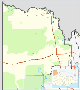
Town in Victoria, Australia
| Tutye Victoria | |||||||||||||||
|---|---|---|---|---|---|---|---|---|---|---|---|---|---|---|---|
 Entering Tutye Entering Tutye | |||||||||||||||
 | |||||||||||||||
| Coordinates | 35°12′53″S 141°29′54″E / 35.21472°S 141.49833°E / -35.21472; 141.49833 | ||||||||||||||
| Population | 20 (2016 census) | ||||||||||||||
| Postcode(s) | 3490 | ||||||||||||||
| Elevation | 96 m (315 ft) | ||||||||||||||
| Location | |||||||||||||||
| LGA(s) | Rural City of Mildura | ||||||||||||||
| State electorate(s) | Mildura | ||||||||||||||
| Federal division(s) | Mallee | ||||||||||||||
| |||||||||||||||
Tutye is a locality situated on the section of the Mallee Highway between Ouyen and the South Australian border in the Sunraysia region of Victoria, Australia. The place by road, is situated about 9 kilometres southeast from Boinka and 12 kilometres northwest from Cowangie.
A Post Office opened on 15 July 1912 when a regular mail service was provided by the opening of the railway line from Ouyen to Murrayville a month earlier. The office closed in 1980. A primary school, Tutye State School, was officially opened in 1920, although it had been in operation since 1914. It no longer exists.
The area of the locality contains the smaller area of Tyalla.
References
- Australian Bureau of Statistics (27 June 2017). "Tutye (State Suburb)". 2016 Census QuickStats. Retrieved 1 September 2020.

- Travelmate
- Phoenix Auctions History, Post Office List, retrieved 10 February 2021
- "Tutye State School". Sunraysia Daily: 2. 29 October 1920.
- "Tutye". Pinnaroo and Border Times: 2. 25 September 1914.
| Localities in the Rural City of Mildura | ||
|---|---|---|
| City |  | |
| Town | ||
| Locality | ||
| ^ - Territory divided with another LGA | ||
This article about a location in the Mallee is a stub. You can help Misplaced Pages by expanding it. |