 Koryn prior to peak intensity on June 24 Koryn prior to peak intensity on June 24 | |
| Meteorological history | |
|---|---|
| Formed | June 15, 1993 |
| Dissipated | June 29, 1993 |
| Violent typhoon | |
| 10-minute sustained (JMA) | |
| Highest winds | 195 km/h (120 mph) |
| Lowest pressure | 905 hPa (mbar); 26.72 inHg |
| Category 4-equivalent super typhoon | |
| 1-minute sustained (SSHWS/JTWC) | |
| Highest winds | 240 km/h (150 mph) |
| Overall effects | |
| Fatalities | 37 direct |
| Damage | $224 million (1993 USD) |
| Areas affected | Caroline Islands, Philippines, People's Republic of China, Vietnam |
| IBTrACS | |
Part of the 1993 Pacific typhoon season | |
Typhoon Koryn, known in the Philippines as Typhoon Goring, was the third named storm, first typhoon and super typhoon of the 1993 Pacific typhoon season. Koryn formed on June 13 and reached super typhoon status on June 26 with winds at 150 mph (240 km/h) and a barometric pressure of 910 millibars. A powerful super typhoon, Koryn caused serious damage across the Caroline Islands, the Philippines, and the People's Republic of China, leaving 37 people dead and $14 million (1993 USD). It was the most intense tropical cyclone worldwide in 1993.
Meteorological history

Map key Saffir–Simpson scale Tropical depression (≤38 mph, ≤62 km/h)
Tropical storm (39–73 mph, 63–118 km/h)
Category 1 (74–95 mph, 119–153 km/h)
Category 2 (96–110 mph, 154–177 km/h)
Category 3 (111–129 mph, 178–208 km/h)
Category 4 (130–156 mph, 209–251 km/h)
Category 5 (≥157 mph, ≥252 km/h)
Unknown Storm type
 Tropical cyclone
  Subtropical cyclone
  Extratropical cyclone, remnant low, tropical disturbance, or monsoon depression
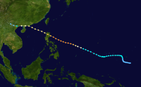
 An area of low pressure formed near the Caroline Islands on June 15 and moved northward and then westward where it continued to strengthen and became Tropical Storm Koryn on June 17. Then, Koryn started to move northwestwards. On June 23, satellite photos revealed a 10-mile (16 km) diameter eye forming in the developing storm and winds of 75 mph (121 km/h) were also detected, prompting forecasters to upgrade Koryn to typhoon status.
The next day, Koryn rapidly intensified to become the first super typhoon of the season with winds of 150 mph (240 km/h) and a minimal pressure of 905 millibars. The rapid intensification occurred within a 23-hour period.
After peaking, the typhoon began to weaken and started making landfall in the northern Philippines. After making landfall in the northern Philippines on June 26, Koryn entered the South China Sea as a Category 2 typhoon. The typhoon maintained the intensity until it made landfall. Moving at 30 km/h, the storm made landfall near Hong Kong and weakened into a strong tropical storm until the storm dissipated on June 29.
Preparations
Officials at the Joint Typhoon Warning Center issued a tropical storm warning for the Caroline Islands as Tropical Depression 6W formed. In China, officials began to issue gale warnings as the typhoon was 220 miles (350 km) from making landfall. Reports of evacuations from the Philippines before the storm are unavailable.
Impact
When Koryn passed over Ulithi, an island in the Caroline Islands, it brought 5.53 inches (140 mm) of rain and 70 mph (110 km/h) winds. There were no reports of fatalities or injuries and minimal roof and crop damage was the only damage. In the Philippines, the storm caused extensive landslides that left 28-51 people dead, injuring 109 others and left $14 million (1993 USD) in damage. The Philippine government declared 16 provinces disaster areas after the storm. In Hong Kong, a weather station recorded winds up to 70 mph (110 km/h) and a high rainfall total of 29.1 inches (74 cm). In Macau, the storm caused extensive flooding which forced over 600 people to seek shelter. High winds also force a highway bridge to close. Koryn also brought a storm tide of 2–3 meters above normal along the coast of China. Damage in China was severe. In Guangdong, winds of at least tropical storm force and heavy rains damaged crops, destroyed or severely damaged over 378,000 homes and buildings which affected over 5.3 million people. Total damage in China was over 1.2 billion RMB (US$210 million).
See also
References
- ^ 1993 JTWC Report on Koryn Archived 2011-06-07 at the Wayback Machine URL Accessed: May 30, 2006
- Unisys best track data on Koryn Archived 2007-03-11 at the Wayback Machine URL Accessed: May 30, 2006
- ^ HKO Report on Koryn URL Accessed: May 30, 2006