| This article needs additional citations for verification. Please help improve this article by adding citations to reliable sources. Unsourced material may be challenged and removed. Find sources: "Unpa County" – news · newspapers · books · scholar · JSTOR (February 2022) (Learn how and when to remove this message) |
| Ŭnp'a County 은파군 | |
|---|---|
| County | |
| Korean transcription(s) | |
| • Hanja | 銀波郡 |
| • McCune-Reischauer | Ŭnp'a-gun |
| • Revised Romanization | Eunpa-gun |
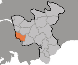
 Map of North Hwanghae showing the location of Unpa Map of North Hwanghae showing the location of Unpa | |
| Country | North Korea |
| Province | North Hwanghae Province |
| Area | |
| • Total | 389 km (150 sq mi) |
| Population | |
| • Total | 110,988 |
| • Density | 290/km (740/sq mi) |
Ŭnp'a County is a county in North Hwanghae province, North Korea.
Administrative divisions
Ŭnp'a county is divided into 1 ŭp (town), 1 rodongjagu (workers' districts) and 15 ri (villages):
|
|
Transportation
Ŭnp'a county is served by the Hwanghae Ch'ŏngnyŏn and Ŭllyul lines of the Korean State Railway.
References
| North Hwanghae Province | ||
|---|---|---|
| Capital |  | |
| Cities | ||
| Counties | ||
This North Korea location article is a stub. You can help Misplaced Pages by expanding it. |