Town in New South Wales, Australia
| Uralba New South Wales | |||||||||||||||
|---|---|---|---|---|---|---|---|---|---|---|---|---|---|---|---|
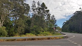
 Uralba Road, 2023 Uralba Road, 2023 | |||||||||||||||
 | |||||||||||||||
| Coordinates | 28°52′17″S 153°28′53″E / 28.87139°S 153.48139°E / -28.87139; 153.48139 | ||||||||||||||
| Population | 266 (SAL 2021) | ||||||||||||||
| Postcode(s) | 2477 | ||||||||||||||
| Location | |||||||||||||||
| LGA(s) | Ballina Shire | ||||||||||||||
| |||||||||||||||
Uralba is a rural locality located on the Far North Coast of New South Wales (in Australia). Its name means "place of plenteous quartz stones".
Administratively it is part of the Ballina Shire. It is located about 14 kilometres (8.7 mi) west from Ballina. Sydney, the state capital, is located approximately 736 kilometres (457 mi) or 8.5 hours car drive south.
Demographics
In the 2016 census, Uralba was represented as a State suburb (SSC14050). It had a population 216 in 69 families. The median age was 54 years. Most people living in Uralba were born in Australia (84%). In the 2021 census, Uralba's population had increased to 266.
Economy
According to the 2016 census, the median household income was $1402 per week.
There were 99 people employed in 2016, and 10 people unemployed. The most common occupations were Professionals (30%); Managers (15%); Community and Personal Service Workers (11%); Sales Workers (11%) and Labourers(11%). The top 5 industries for employment were Fruit and Tree Nut Growing (9%), Local Government Administration (9%), Other Allied Health Services (7%), Road and Bridge Construction (5%) and Site Preparation Services (5%).
Housing
In the 2016 census, the median housing loan repayment was $1,967 per month. The median rent was $225 per week. This equated to just over 15% of median household income. The average household size was 2.5 persons.
Environment
Uralba Nature Reserve, a 288 hectares (710 acres) nature reserve was gazetted as a State Forest in 1910 and as a nature reserve in 1975.
See also
- HMAS Uralba was an auxiliary minefield tender and armament stores carrier operated by the Royal Australian Navy (RAN) during World War II.
References
- Australian Bureau of Statistics (28 June 2022). "Uralba (suburb and locality)". Australian Census 2021 QuickStats. Retrieved 28 June 2022.

- Geographic Names Board of NSW. "GEOGRAPHICAL NAMES REGISTER EXTRACT". Retrieved 16 January 2019.
Meaning:For: a place of plenteous quartz stones. (Antropological Society of Australasia). Also: said to refer to quartz pebbles. (Richmond Tweed Regional Library & Richmond River Historical Society. 1983). Also; 'a hollow or basin'. (M.Sharpe).
- ^ "2016 Uralba". Australian Bureau of Statistics. Archived from the original on 29 July 2018. Retrieved 3 September 2024.
- "2021 Uralba, Census All persons QuickStats". Australian Bureau of Statistics. Retrieved 3 September 2024.
- "Uralba Nature Reserve". NSW National Parks. Retrieved 16 January 2022.
This Northern Rivers geography article is a stub. You can help Misplaced Pages by expanding it. |