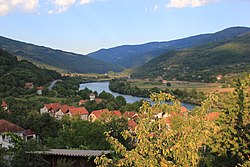
Village in Federation of Bosnia and Herzegovina, Bosnia and Herzegovina
| Ustikolina Устиколина | |
|---|---|
| Village | |
 Drina River in Ustikolina Drina River in Ustikolina | |
 | |
| Coordinates: 43°35′N 18°47′E / 43.583°N 18.783°E / 43.583; 18.783 | |
| Country | Bosnia and Herzegovina |
| Entity | Federation of Bosnia and Herzegovina |
| Canton | Bosnian-Podrinje Goražde |
| Municipality | Foča-Ustikolina |
| Area | |
| • Total | 2.78 sq mi (7.19 km) |
| Population | |
| • Total | 882 |
| • Density | 320/sq mi (120/km) |
| Time zone | UTC+1 (CET) |
| • Summer (DST) | UTC+2 (CEST) |
Ustikolina (Serbian Cyrillic: Устиколина) is a village and the seat of the municipality of Foča-Ustikolina, Federation of Bosnia and Herzegovina, Bosnia and Herzegovina.
A proposal to dam the Drina River at Ustikolina for a hydroelectric power station was rejected by the municipal authorities in October 2006.
History
Ustikolina has been inhabited since the ancient period, as evidenced by the foundings of Roman coins made of bronze and copper dating from the period between the second and fourth centuries. In addition, Roman tegula-bricks and Roman ceramics were found. Near Cvilin, archaeologists found the remains of Roman villas with floor mosaics, bronze dishes and tombstones with Roman inscriptions. It got its name from the river Kolina, so the name Ustikolina means "Mouth of the Kolina". Ustikolina is first mentioned in historical sources in the Chronicles of Pope Dukljanin, where it is recorded that the Serbian emperor Časlav 895-896 defeated the Hungarians (Bosnia was a vassal of Hungary during this period) on the Cvilinski field near Ustikolina. In the local surroundings of Ustikolina there is a necropolis of stećci, which indicates that this area was also inhabited in the Middle Ages by the Bosnian Christians. In Ustikolina the first known mosque in Bosnia and Herzegovina was built in 1443 or 1448, the original builder is unknown but it was later on named after Turhan Emin-beg. The mosque was completely destroyed during World War II, rebuilt after and again destroyed during the Bosnian War. It was rebuilt again in 2007, the original foundations of the mosque have been lost.
Demographics
According to the 2013 census, its population was 882.
| Ethnicity | Number | Percentage |
|---|---|---|
| Bosniaks | 760 | 86.2% |
| Serbs | 99 | 11.2% |
| other/undeclared | 23 | 2.6% |
| Total | 882 | 100% |
References
- Official results from the book: Ethnic composition of Bosnia-Herzegovina population, by municipalities and settlements, 1991. census, Zavod za statistiku Bosne i Hercegovine - Bilten no.234, Sarajevo 1991.
- see page 34
- "Ustikolina i Cvilin- od rimskog novca, do bitke kneza Časlava sa Mađarima i prelaska Turaka preko Drine" (in Bosnian). April 2016.
- "Naseljena Mjesta 1991/2013" (in Bosnian). Statistical Office of Bosnia and Herzegovina. Retrieved 17 April 2022.
| Settlements of Foča-Ustikolina | |
|---|---|
This Bosnian Podrinje Canton geography article is a stub. You can help Misplaced Pages by expanding it. |