| Velika Greda Велика Греда | |
|---|---|
| Village (Selo) | |
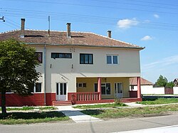
 The health center in the village The health center in the village | |
   | |
| Coordinates: 45°14′22″N 21°01′27″E / 45.23944°N 21.02417°E / 45.23944; 21.02417 | |
| Country | |
| Province | |
| District | South Banat |
| Municipality | |
| Elevation | 74 m (243 ft) |
| Population | |
| • Velika Greda | 1,374 |
| Time zone | UTC+1 (CET) |
| • Summer (DST) | UTC+2 (CEST) |
| Postal code | 26366 |
| Area code | +381(0)13 |
| Car plates | VŠ |
Velika Greda (Serbian Cyrillic: Велика Греда) is a village in Serbia. It is situated in the Plandište municipality, in the South Banat District, Vojvodina province. The village has a Serb ethnic majority (69,86%) with a present Hungarian (12.29%) and a Macedonian minority (9.89%), and its population as of the 2002 census, was 1,374 people.
Name
In Serbian, the village is known as Velika Greda (Велика Греда), in Hungarian as Györgyháza, and in German as Georgshausen.
Historical population
- 1961: 1,942
- 1971: 1,775
- 1981: 1,585
- 1991: 1,508
- 2002: 1,374
References
- Slobodan Ćurčić, Broj stanovnika Vojvodine, Novi Sad, 1996.
See also
| Cities, towns and villages in the South Banat District | |
|---|---|
| Pančevo | |
| Alibunar | |
| Bela Crkva | |
| Vršac | |
| Kovačica | |
| Kovin | |
| Opovo | |
| Plandište | |
| (*) bold are municipalities or cities | |
This South Banat District, Vojvodina location article is a stub. You can help Misplaced Pages by expanding it. |