Township in Illinois, United States
| Vernon Township | |
|---|---|
| Township | |
 Location in Lake County Location in Lake County | |
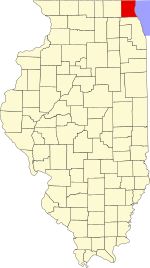
 Lake County's location in Illinois Lake County's location in Illinois | |
| Coordinates: 42°11′49″N 87°56′33″W / 42.19694°N 87.94250°W / 42.19694; -87.94250 | |
| Country | United States |
| State | Illinois |
| County | Lake |
| Established | November 6, 1849 |
| Government | |
| • Supervisor | Tim Kobler |
| • Assessor | Curtis Perlman |
| Area | |
| • Total | 36.2 sq mi (93.8 km) |
| • Land | 35.8 sq mi (92.7 km) |
| • Water | 0.4 sq mi (1.1 km) |
| Elevation | 669 ft (204 m) |
| Population | |
| • Estimate | 67,833 |
| Time zone | UTC-6 (CST) |
| • Summer (DST) | UTC-5 (CDT) |
| FIPS code | 17-097-77668 |
| Website | www |
Vernon Township is a township in Lake County, Illinois, USA. As of the 2010 census, its population was 67,095. The name "Vernon Township" comes from George Washington's estate, Mount Vernon.
Geography
Vernon Township covers an area of 36.2 square miles (93.8 km); of this, 0.42 square miles (1.1 km) or 1.14 percent is water. The stream of Indian Creek runs through this township. All communities within the township are North Central suburbs of Chicago.
Cities and towns
- Arlington Heights (northern edge of municipality)
- Bannockburn (western edge of municipality)
- Buffalo Grove (north three-quarters of Village)
- Indian Creek
- Lake Forest (west edge of Village)
- Lincolnshire (vast majority)
- Long Grove (east half)
- Mettawa (south half)
- Mundelein (southeast edge)
- Riverwoods (west three-quarters)
- Vernon Hills (south half)
- Wheeling (north edge)
Unincorporated towns
- Half Day
- Prairie View
Adjacent townships
- Libertyville Township (north)
- Shields Township (northeast)
- West Deerfield Township (east)
- Northfield Township, Cook County (southeast)
- Wheeling Township, Cook County (south)
- Palatine Township, Cook County (southwest)
- Ela Township (west)
- Fremont Township (northwest)
Cemeteries
The township contains eight cemeteries: Diamond Lake, Gridley, Knopf, Long Grove, Lutheran, Vernon, Willow Lawn and Zion City.
Major highways
- Interstate 94
- U.S. Route 45
- Illinois State Route 21
- Illinois State Route 22
- Illinois State Route 53
- Illinois State Route 60
- Illinois State Route 83
Airports and landing strips
- Chicagoland Airport (historical)
Demographics
| Census | Pop. | Note | %± |
|---|---|---|---|
| 2016 (est.) | 67,833 | ||
| U.S. Decennial Census | |||
References
- ^ "Population and Housing Unit Estimates". Retrieved June 9, 2017.
- ^ "Geographic Identifiers: 2010 Demographic Profile Data (G001): Vernon township, Lake County, Illinois". U.S. Census Bureau, American Factfinder. Archived from the original on February 12, 2020. Retrieved December 19, 2012.
- Halsey 1912, p. 532.
- "Flying Magazine". Flying: 63. February 1964. ISSN 0015-4806. Retrieved August 27, 2015.
- "Census of Population and Housing". Census.gov. Retrieved June 4, 2016.
- Halsey, John Julius (1912). A history of Lake County, Illinois. Roy S. Bates. Retrieved July 26, 2021.
External links
| Municipalities and communities of Lake County, Illinois, United States | ||
|---|---|---|
| County seat: Waukegan | ||
| Cities | ||
| Villages |
| |
| Townships | ||
| CDPs | ||
| Other unincorporated communities | ||
| Former settlements | ||
| Footnotes | ‡This populated place also has portions in an adjacent county or counties | |
