| Virginia Dare Memorial Bridge | |
|---|---|
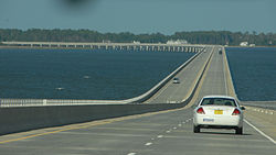
 Image from the bridge Image from the bridge | |
| Coordinates | 35°53′13″N 75°43′57″W / 35.887°N 75.73245°W / 35.887; -75.73245 |
| Carries | |
| Crosses | Croatan Sound |
| Locale | Dare County |
| Named for | Virginia Dare |
| Owner | NCDOT |
| Maintained by | NCDOT |
| Characteristics | |
| Design | Segmented girder |
| Material | Prestressed concrete |
| Total length | 27,581.4 feet (8,406.8 m) |
| Width | 67.6 feet (20.6 m) |
| Clearance below | 65.9 feet (20.1 m) |
| History | |
| Constructed by | Balfour Beatty Construction |
| Construction cost | $90 million |
| Opened | August 16, 2002 |
| Statistics | |
| Daily traffic | 4,000 (as of 2010) |
| Location | |
| References | |
The Virginia Dare Memorial Bridge is a four-lane automobile bridge in Dare County, North Carolina, spanning the Croatan Sound between Manns Harbor and Roanoke Island. The bridge carries US 64 Bypass and is utilized by local and seasonal tourist traffic.
The bridge is dedicated to the memory of Virginia Dare, the first English child born in the Americas, in 1587.
At a length of 5.2 miles (8.4 km), the Virginia Dare Memorial Bridge is the longest in the state. It travels over .75 miles (1.2 km) of wetlands, with the remaining 4.45 miles (7.2 km) over the Croatan Sound. The bridge rises to 65 feet (20 m) at its apex and is supported by 88 concrete columns and more than 2,000 pilings, which extend 100 feet (30 m) below the water. The bridge deck has 7,250 tons of epoxy-coated reinforcement steel and was designed with a 100-year life span.
The bridge complements and runs parallel to the older William B. Umstead Bridge, which carries US 64 between Manns Harbor and Manteo and is located farther north. The bridge is the westernmost in a series of three, along with the Washington Baum Bridge and Melvin R. Daniels Bridge, connecting the North Carolina mainland with the Outer Banks communities via US 64 and US 64 Bypass.
History
In 1996, two hurricanes forced evacuation of the Outer Banks area during peak tourist season. The existing William B. Umstead Bridge, built in 1955 and having only two lanes, was unable to handle the high volume of traffic during the evacuation. To help alleviate traffic congestion and provide an additional emergency evacuation route from the Outer Banks, planning for a new bridge began in earnest. In January 1997, Wilbur Smith Associates was selected for the design of the bridge. In April 1998, Balfour Beatty Construction was awarded the prime construction contract.
On August 16, 2002, the bridge was dedicated by NCDOT Secretary Lyndo Tippett and was opened that day. The bridge initially carried US 64 Bypass and US 264 Bypass; but in September 2003, the US 264 Bypass designation was removed.
See also
References
- "US64/US264 over Croatan Sound". Uglybridges.com. Retrieved April 21, 2014.
- Baughn, James; et al. "Virginia Dare Memorial Bridge". Bridgehunter.com. Historic Bridge Foundation. Retrieved 2013-06-09.
- ^ "Secretary Lyndo Tippett – 2002 Virginia Dare Memorial Bridge Dedication Ceremony" (Press release). North Carolina Department of Transportation. August 16, 2002. Retrieved June 21, 2015.
- ^ Randy Midgett and Don Barber (May 16, 2003). "The perfect dare". Roads & Bridges. Retrieved June 21, 2015.
- "Route Change (2003-09-15)" (PDF). North Carolina Department of Transportation. September 15, 2003. Retrieved June 21, 2015.
External links
 Media related to Virginia Dare Memorial Bridge at Wikimedia Commons
| Outer Banks of North Carolina and Virginia | |
|---|---|
| Landforms | |
| Places | |
| Waterways | |
| Lighthouses | |
| Protected areas and wildlife |
|
| Transportation | |
| History | |
| Weather | |
- Buildings and structures in Dare County, North Carolina
- Bridges completed in 2002
- Road bridges in North Carolina
- Transportation in Dare County, North Carolina
- 2002 establishments in North Carolina
- U.S. Route 64
- Bridges of the United States Numbered Highway System
- Roanoke Island
- Concrete bridges in the United States
- Girder bridges in the United States