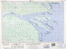
Wabuda Island is the third largest island in the Fly River delta, Papua New Guinea, after Kiwai Island and Purutu Island. Its area is 109 km (42 sq mi).
Administratively, the island belongs to Kiwai Rural LLG in South Fly District of Western Province.
See also
| Islands of Papua New Guinea | |
|---|---|
| Bismarck Archipelago | |
| Louisiade Archipelago | |
| North Solomon Islands | |
8°23′S 143°37′E / 8.383°S 143.617°E / -8.383; 143.617
This Gulf Province geography article is a stub. You can help Misplaced Pages by expanding it. |