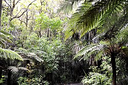
Place in Northland Region, New Zealand
| Waipoua Settlement | |
|---|---|
 Waipoua Forest Waipoua Forest | |
 | |
| Coordinates: 35°56′18″S 173°52′18″E / 35.93833°S 173.87167°E / -35.93833; 173.87167 | |
| Country | New Zealand |
| Region | Northland Region |
| District | Kaipara District |
| Postcode(s) | 0310 |
Waipoua Settlement is a rural community in the Kaipara District of Northland, in New Zealand's North Island.
It includes the Waipoua Forest, one of the best preserved examples of a kauri forest in New Zealand. It is notable for having two of the largest living kauri trees, Tāne Mahuta and Te Matua Ngahere. Approximately 200,000 people visit Tāne Mahuta every year.
The area has two marae belonging to Te Roroa: Matatina Marae and Tuohu meeting house, and Pananawe Marae and Te Taumata o Tiopira Kinaki meeting house.
Notes
- Alicia Burrow (6 May 2015). "Kaipara leads the way in 'visitor' growth". Stuff.co.nz. Retrieved 23 November 2018.
- "Waipoua Forest: Places to go in Northland". Department of Conservation. Retrieved 23 November 2018.
- "Waipoua Forest: Places to go in Northland". Department of Conservation. Retrieved 23 November 2018.
- "Te Kāhui Māngai directory". tkm.govt.nz. Te Puni Kōkiri.
- "Māori Maps". maorimaps.com. Te Potiki National Trust.
35°56′S 173°53′E / 35.933°S 173.883°E / -35.933; 173.883
This Northland Region-related geography article is a stub. You can help Misplaced Pages by expanding it. |