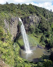
Waterfall in Waikato, New Zealand
| Wairēinga / Bridal Veil Falls | |
|---|---|
| Māori: Wairēinga | |
 Bridal Veil Falls, as seen from the second lookout. Bridal Veil Falls, as seen from the second lookout. | |
| Location | Waikato, New Zealand |
| Coordinates | 37°54′31″S 174°53′48″E / 37.908518°S 174.896636°E / -37.908518; 174.896636 |
| Type | Plunge |
| Total height | 55 metres (180 ft) |
| Watercourse | Pakoka River |

Bridal Veil Falls (officially Wairēinga / Bridal Veil Falls; Māori: Wairēinga) is a plunge waterfall located along the Pakoka River in the Waikato area of New Zealand. The waterfall is 55 m (180 ft) high, and has over time caused the formation of a large pool at the base of the waterfall. The falls are in the 217 ha (540 acres) Wairēinga Scenic Reserve (created in 1884) with tawa-dominated forest.
Formation
The water cascades over a basalt cliff, formed by volcanic activity, when an Okete Volcanics vent, on the 226 m (741 ft) hill just to the north, erupted 2.57 million years ago and blocked the valley.
Access and recreational activities
Approximately 15 minutes from the nearby town of Raglan, the falls are an easy 10-minute walk through native bush, along the Pakoka River. Facilities include parking, long-drop toilets and four lookout platforms. River crossings are bridged. It is a steep descent to the falls base by 261 steps cut into a well maintained path.
400m beyond Bridal Veil car park, where Kawhia Rd becomes gravel, is the start of the 6 km Pipiwharauroa Way walking and cycling track.
Swimming and rock climbing
- The pool should not be swum in as water quality does not meet health standards for swimming.
- Abseiling and rock climbing are not permitted due to damage to endangered plant life (the threatened spider orchid Corybas “Kaitarakihi” (Corybas aff. rivularis)).

See also
References
- ^ DoC 2013 consultation document page 97 Archived 22 February 2013 at the Wayback Machine
- CW Vennell & Susan Williams (1976). Raglan County Hills and Sea 1876–1976. Wilson & Horton for Raglan County Council. p. 292. ISBN 0868640026.
- Te Ara Encyclopedia – formation of waterfalls
- Stipp, J. J. (1968). The geochronology and petrogenesis of the Cenozoic volcanics of North Island. New Zealand : Canberra, Australian National University.
- Barry Clayton Waterhouse, P. J. White (1994). Geology of the Raglan-Kawhia Area. Institute of Geological & Nuclear Sciences (N.Z.). pp. map. ISBN 0-478-08837-X.
- Tramper.co.nz
- "New Stairs at Waireinga-Bridal Veil Falls". www.raglan23.co.nz. 10 February 2010. Archived from the original on 22 February 2013. Retrieved 25 March 2016.
- Department of Conservation – area guide
- DoC 2013 consultation document page 97 Archived 22 February 2013 at the Wayback Machine
External links
- 1898 photograph in Auckland Weekly News
- Accounts of visits in 1893, before formation of the road, and in 1900
| Neighbouring areas | ||||||||||||||||
|---|---|---|---|---|---|---|---|---|---|---|---|---|---|---|---|---|
| ||||||||||||||||