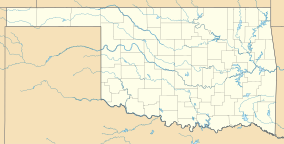
| Walnut Creek State Park | |
|---|---|
 | |
| Location | Osage County, Oklahoma, United States |
| Nearest city | Prue, OK |
| Coordinates | 36°14′42″N 96°17′01″W / 36.245°N 96.283611°W / 36.245; -96.283611 |
| Area | 1,429 acres (578 ha) |
| Established | 1966 |
Walnut Creek State Park was a former Oklahoma State Park on the north shore of Lake Keystone, 4 miles (6.4 km) west of Prue in Osage County, Oklahoma. The park was created in 1966, and contains 1,400 acres. Facilities include sandy beaches, a softball field, picnic shelter with tables, RV hookups, and tent sites and restrooms. The 15 miles (24 km) long Sand Plum Trail is open to hikers, horseback riders, and mountain bikers. The park has an equestrian campground, but visitors must bring their own horses because horses are not available for rent in the park. The park was open all year.
The state of Oklahoma officially closed this park permanently on October 1, 2014. The U.S. Army Corps of Engineers is responsible for selecting the final disposition of what remains of the facility.
References
- "Walnut Creek State Park". Shop Oklahoma.
- "Walnut Creek State Park". Oh Ranger!.
- "Walnut Creek State Park". Oklahoma Tourism and Recreation Department. Retrieved January 6, 2013.
- "Walnut Creek State Park". Keystone OK.
- Logan, Layden, " Uncertainty Looms Over Walnut Creek’s Somber Final Weekend As A State Park." October 2, 2014. Accessed August 3, 2017.
This article related to a protected area in Oklahoma is a stub. You can help Misplaced Pages by expanding it. |