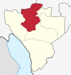
| Wanging'ombe District | |
|---|---|
| District | |
 location in Njombe Region location in Njombe Region | |
| Coordinates: 08°51′S 034°38′E / 8.850°S 34.633°E / -8.850; 34.633 | |
| Country | |
| Region | Njombe Region |
| Area | |
| • Total | 3,437 km (1,327 sq mi) |
| Population | |
| • Total | 191,506 |
| • Density | 56/km (140/sq mi) |
Wanging'ombe District is one of the six districts of the Njombe Region of Tanzania, East Africa. The administrative seat is in Igwachanya. According to the 2022 Tanzania National Census, the population of Igunga District was 191,506 in 2022.
History
Wanging'ombe District was formally established when it was gazetted in March 2012. It was created out of part of the old Njombe District that had been in Iringa Region.
Wards
As of 2015, Wanging'ombe District was administratively divided into 21 wards:
- Saja
- Uhenga
- Kijombe
- Wanging'ombe
- Ilembula
- Udonja
- Uhambule
- Usuka
- Igwachanya
- Mdandu
- Itulahumba
- Igima
- Imalinyi
- Ulembwe
- Makoga
- Kipengele
- Igosi
- Wangama
- Kidugala
- Luduga
- Malangali
Notes
- ^ Staff (9 March 2012). "Tanzania: State Gazettes New Regions, Districts". Daily News. Dar es Salaam, Tanzania.
- "Wanging'ombe (District, Tanzania) - Population Statistics, Charts, Map and Location". www.citypopulation.de. Retrieved 2024-02-11.
- Wanging'ombe District Council: Council Strategic Plan for the Year 2015/2016 – 2019/2020 (PDF). United Republic of Tanzania, President's Office, Regional Administration and Local Government. 2015. p. 2. Retrieved January 31, 2024.
| Districts of Njombe Region, Tanzania | |
|---|---|
This Njombe Region location article is a stub. You can help Misplaced Pages by expanding it. |