| Ursynów | |
|---|---|
| Warsaw District | |
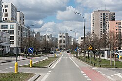
 Cynamonowa Street Cynamonowa Street | |
 Flag Flag Coat of arms Coat of arms | |
 Location of Ursynów within Warsaw Location of Ursynów within Warsaw | |
| Coordinates: 52°8.5′N 21°2′E / 52.1417°N 21.033°E / 52.1417; 21.033 | |
| Country | |
| Voivodeship | Masovian |
| County/City | Warsaw |
| Notable landmarks | J. Ursyn Niemcewicz park, 19th century Służew fort, PAN botanical garden, Służewiec horseracing track, Natolin Park, Kabaty Forest |
| Government | |
| • Mayor | Robert Kempa |
| Area | |
| • Total | 43.73 km (16.88 sq mi) |
| Population | |
| • Total | 150,668 |
| Time zone | UTC+1 (CET) |
| • Summer (DST) | UTC+2 (CEST) |
| Area code | +48 22 |
| Website | ursynow |
Ursynów (pronounced [urˈsɨnuf] ) is the southernmost district of Warsaw. With a surface area of 43.7 km (16.9 sq mi), it is the third largest district in Warsaw, comprising 8.6% of the city. The district has a population of over 150,000, and is one of the fastest-growing neighbourhoods in Warsaw. Nearly 25% of its inhabitants are below 18 years of age.
The eastern section of Ursynów is heavily built up with blocks of flats, while its western and southern sections are often referred to as Green Ursynów due to its lower population density and broad open spaces and green areas. The neighbourhood is considered the bedroom of Warsaw, and is home to nearly a quarter of the city's post-1989 construction.
Ursynów's southern extremity comprises Kabaty Forest, covering more than 9.2 km (3.6 sq mi). Other popular attractions include the Vistula river escarpment, Natolin palace and Służewiec horseracing track (built in 1939), used not only for its original purpose, but for open-air exhibitions, pop concerts, etc.
Ursynów is served by the Ursynów, Stokłosy, Imielin, Natolin and Kabaty stations of the Warsaw Metro. The Kabaty depot is located in the south of the borough.
Neighbourhoods within the district
- Dąbrówka
- Grabów, Warsaw
- Jeziorki Północne
- Jeziorki Południowe
- Kabaty
- Natolin
- North Ursynów
- Pyry
- Skarpa Powsińska
- Old Służew
- Old Imielin
- Ursynów-Centrum
- Wyczółki
Nature
There are two nature reserves in the district: Stefan Starzyński Kabacki Forest and Skarpa Ursynowska. At Nowoursynowska Street grows Mieszko I, the oldest oak in the Province.
Mayors
- Stanisław Faliński 1994–2002
- Tomasz Sieradz 2002–2003
- Andrzej Machowski 2003–2006
- Tomasz Mencina 2006–2009
- Urszula Kierzkowska 2009–2010
- Piotr Guział 2010–2014
- Robert Kempa 2014–
References
- "Powierzchnia i ludność w przekroju terytorialnym w 2019 roku. Tabl. 21 Powierzchnia, ludność oraz lokaty według gmi". stat.gov.pl. Główny Urząd Statystyczny. Retrieved 2 September 2020.
- Co dalej z najstarszym drzewem w Warszawie?
External links
| Inner city districts |
| ||||||||||||||||||||||
|---|---|---|---|---|---|---|---|---|---|---|---|---|---|---|---|---|---|---|---|---|---|---|---|
| Outer city districts |
| ||||||||||||||||||||||
| Related | |||||||||||||||||||||||
| Ursynów, Warsaw | ||
|---|---|---|
| Neighbourhoods |  | |
| Parks | ||
| Education and science | ||
| Sports | ||
| Religion | ||
| Culture | ||
| Other buildings | ||
| Transport | ||
| Roads | ||
| Geography |
| |