Human settlement in England
| Warton with Lindeth | |
|---|---|
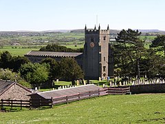
 St Oswald's Church, Warton St Oswald's Church, Warton | |
  | |
| Civil parish | |
| District | |
| Shire county | |
| Region | |
| Country | England |
| Sovereign state | United Kingdom |
| |
Warton with Lindeth was a civil parish in the north of Lancashire, England, from 1866 to 1935. It had an area of 4,141 acres (1,676 ha). It was a township and became a parish in 1866. It was abolished on 1 April 1935, when 3,534 acres (1,430 ha) formed the new civil parish of Warton and 607 acres (246 ha) were added to the civil parish of Silverdale (created 1866). In 1931 the parish had a population of 1694.
In John Marius Wilson's Imperial Gazetteer of England and Wales (1870–72), Lindeth was described as "a hamlet in Warton parish, Lancashire; 4 ½ miles NW of Carnforth".
References
- "Warton with Lindeth Cp/Tn". Vision of Britain. University of Portsmouth. Retrieved 23 November 2014.
- "Population statistics Warton With Lindeth CP/Tn through time". A Vision of Britain through Time. Retrieved 16 May 2024.
- "Descriptive Gazetteer Entry for LINDETH". Vision of Britain. University of Portsmouth. Retrieved 23 November 2014.
This Lancashire location article is a stub. You can help Misplaced Pages by expanding it. |